
Topografische Karte Orofino
Interaktive Karte
Klicken Sie auf die Karte, um die Höhe anzuzeigen.
Über diese Karte
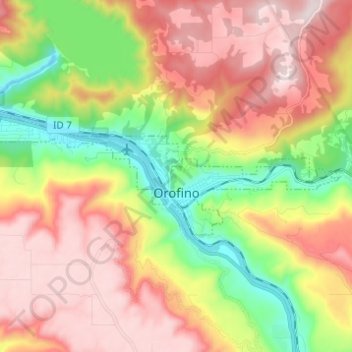
Name: Topografische Karte Orofino, Höhe, Relief.
Ort: Orofino, Clearwater County, Idaho, 83544, United States (46.47097 -116.32122 46.49939 -116.19855)
Durchschnittliche Höhe: 633 m
Minimale Höhe: 293 m
Maximale Höhe: 964 m
Due to the area’s relatively low elevation, the climate is ranked as among the hottest in the summer and the mildest in the winter throughout the entire state. The moderate winters are also influenced by the city’s northwestern location, which places it closer to the Pacific Ocean than many other parts of Idaho. Idaho’s all-time highest temperature of 118 °F or 47.8 °C was recorded at Orofino on July 28, 1934.
Andere topografische Karten
Klicken Sie auf eine Karte, um ihre Topografie, ihre Höhe und ihr Relief anzuzeigen.
Weippe
United States > Idaho > Clearwater County
Weippe, Clearwater County, Idaho, 83553, United States
Durchschnittliche Höhe: 926 m
Ahsahka
United States > Idaho > Clearwater County
Ahsahka, Clearwater County, Idaho, 83520, United States
Durchschnittliche Höhe: 422 m
Elk River
United States > Idaho > Clearwater County
Elk River, Clearwater County, Idaho, 83827, United States
Durchschnittliche Höhe: 907 m
Pierce
United States > Idaho > Clearwater County
Pierce, Clearwater County, Idaho, 83546, United States
Durchschnittliche Höhe: 1.004 m
Orofino
United States > Idaho > Clearwater County > Orofino > Orofino
Orofino, Clearwater County, Idaho, 83544, United States
Durchschnittliche Höhe: 627 m