
Topografische Karte Navalón
Interaktive Karte
Klicken Sie auf die Karte, um die Höhe anzuzeigen.
Über diese Karte
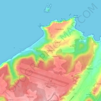
Name: Topografische Karte Navalón, Höhe, Relief.
Ort: Navalón, Castrillón, Asturias, 33457, España (43.55366 -6.05117 43.59366 -6.01117)
Durchschnittliche Höhe: 56 m
Minimale Höhe: -2 m
Maximale Höhe: 141 m
Andere topografische Karten
Klicken Sie auf eine Karte, um ihre Topografie, ihre Höhe und ihr Relief anzuzeigen.
La Fundición
España > Asturias > Castrillón
La Fundición, Castrillón, Asturias, 33405, España
Durchschnittliche Höhe: 20 m
La Cabaña
España > Asturias > Castrillón
La Cabaña, Castrillón, Asturias, 33457, España
Durchschnittliche Höhe: 110 m
Los Pozos
España > Asturias > Castrillón
Los Pozos, Castrillón, Asturias, 33125, España
Durchschnittliche Höhe: 61 m
Piedras Blancas
España > Asturias > Castrillón
Piedras Blancas, Castrillón, Asturias, 33450, España
Durchschnittliche Höhe: 65 m