
Topografische Karte Gold Creek
Interaktive Karte
Klicken Sie auf die Karte, um die Höhe anzuzeigen.
Über diese Karte
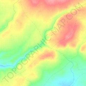
Name: Topografische Karte Gold Creek, Höhe, Relief.
Ort: Gold Creek, Fremont County, Wyoming, United States (42.45237 -108.91907 42.45244 -108.91907)
Durchschnittliche Höhe: 2.461 m
Minimale Höhe: 2.408 m
Maximale Höhe: 2.504 m
Andere topografische Karten
Klicken Sie auf eine Karte, um ihre Topografie, ihre Höhe und ihr Relief anzuzeigen.
Pylon Peak
United States > Wyoming > Fremont County
Pylon Peak, Fremont County, Wyoming, United States
Durchschnittliche Höhe: 3.388 m
Mount Burwell
United States > Wyoming > Fremont County
Mount Burwell, Fremont County, Wyoming, United States
Durchschnittliche Höhe: 3.387 m
Collins Place
United States > Wyoming > Fremont County
Collins Place, Fremont County, Wyoming, United States
Durchschnittliche Höhe: 2.146 m
Pavillion
United States > Wyoming > Fremont County
Pavillion, Fremont County, Wyoming, 82523, United States
Durchschnittliche Höhe: 1.665 m
Chimney Rock
United States > Wyoming > Fremont County
Chimney Rock, Fremont County, Wyoming, United States
Durchschnittliche Höhe: 3.627 m
Mount Popo Agie
United States > Wyoming > Fremont County
Mount Popo Agie, Fremont County, Wyoming, United States
Durchschnittliche Höhe: 2.848 m
Riverton
United States > Wyoming > Fremont County > Riverton
Riverton, Fremont County, Wyoming, United States
Durchschnittliche Höhe: 1.529 m
Lander
United States > Wyoming > Fremont County
Lander, Fremont County, Wyoming, 82520, United States
Durchschnittliche Höhe: 1.759 m
Jeffrey City
United States > Wyoming > Fremont County
Jeffrey City, Fremont County, Wyoming, 82310, United States
Durchschnittliche Höhe: 1.970 m
Sweetwater Station
United States > Wyoming > Fremont County
Sweetwater Station, Fremont County, Wyoming, United States
Durchschnittliche Höhe: 2.021 m