
Topografische Karte Saint-Sauveur
Interaktive Karte
Klicken Sie auf die Karte, um die Höhe anzuzeigen.
Über diese Karte
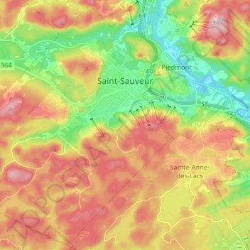
Name: Topografische Karte Saint-Sauveur, Höhe, Relief.
Durchschnittliche Höhe: 294 m
Minimale Höhe: 154 m
Maximale Höhe: 443 m
Andere topografische Karten
Klicken Sie auf eine Karte, um ihre Topografie, ihre Höhe und ihr Relief anzuzeigen.
Piedmont
Canada > Quebec > Les Pays-d'en-Haut
Piedmont, Les Pays-d'en-Haut, Laurentides, Quebec, J0R 1K0, Canada
Durchschnittliche Höhe: 254 m
Sainte-Adèle
Canada > Quebec > Les Pays-d'en-Haut
Sainte-Adèle, Les Pays-d'en-Haut, Laurentides, Quebec, Canada
Durchschnittliche Höhe: 336 m
Mont Baldy
Canada > Quebec > Les Pays-d'en-Haut > Sainte-Adèle
Mont Baldy, Sainte-Adèle, Les Pays-d'en-Haut, Laurentides, Quebec, J8B 2N6, Canada
Durchschnittliche Höhe: 284 m
Sainte-Anne-des-Lacs
Canada > Quebec > Les Pays-d'en-Haut
Sainte-Anne-des-Lacs, Les Pays-d'en-Haut, Laurentides, Quebec, J0R 1B0, Canada
Durchschnittliche Höhe: 287 m
Club de Plein Air Saint Adolphe d'Howard
Canada > Quebec > Les Pays-d'en-Haut > Saint-Adolphe-d'Howard
Club de Plein Air Saint Adolphe d'Howard, Saint-Adolphe-d'Howard, Les Pays-d'en-Haut, Laurentides, Quebec, Canada
Durchschnittliche Höhe: 399 m
Saint-Adolphe-d'Howard
Canada > Quebec > Les Pays-d'en-Haut > Saint-Adolphe-d'Howard
Saint-Adolphe-d'Howard, Les Pays-d'en-Haut, Laurentides, Quebec, J0T 2B0, Canada
Durchschnittliche Höhe: 424 m
Lac Masson
Canada > Quebec > Les Pays-d'en-Haut > Sainte-Marguerite-du-Lac-Masson
Lac Masson, Sainte-Marguerite-du-Lac-Masson, Les Pays-d'en-Haut, Laurentides, Quebec, Canada
Durchschnittliche Höhe: 349 m