
Topografische Karte Hood River
Interaktive Karte
Klicken Sie auf die Karte, um die Höhe anzuzeigen.
Über diese Karte
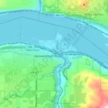
Name: Topografische Karte Hood River, Höhe, Relief.
Ort: Hood River, Hood River County, Oregon, United States (45.69298 -121.56508 45.72651 -121.49538)
Durchschnittliche Höhe: 112 m
Minimale Höhe: 14 m
Maximale Höhe: 504 m
Temperatures for the year as a whole are slightly cooler than in most other low-elevation towns in the region, especially at night because of air drainage off the surrounding mountains.
Andere topografische Karten
Klicken Sie auf eine Karte, um ihre Topografie, ihre Höhe und ihr Relief anzuzeigen.
Parkdale
United States > Oregon > Hood River County > Parkdale
Parkdale, Hood River County, Oregon, United States
Durchschnittliche Höhe: 538 m
Odell
United States > Oregon > Hood River County
Odell, Hood River County, Oregon, United States
Durchschnittliche Höhe: 244 m
Badger Lake Dam
United States > Oregon > Hood River County
Badger Lake Dam, Hood River County, Oregon, United States
Durchschnittliche Höhe: 1.565 m
Government Cove
United States > Oregon > Hood River County > Cascade Locks
Government Cove, Cascade Locks, Hood River County, Oregon, United States
Durchschnittliche Höhe: 89 m
Cascade Locks Marine Park
United States > Oregon > Hood River County > Cascade Locks
Cascade Locks Marine Park, Cascade Locks, Hood River County, Oregon, United States
Durchschnittliche Höhe: 72 m
Mount Hood
United States > Oregon > Hood River County
Mount Hood, Hood River County, Oregon, United States
Durchschnittliche Höhe: 2.716 m
Dee
United States > Oregon > Hood River County
Dee, Hood River County, Oregon, United States
Durchschnittliche Höhe: 424 m
Columbia River
United States > Oregon > Hood River County > Cascade Locks
Columbia River, Cascade Locks, Hood River County, Oregon, United States
Durchschnittliche Höhe: 543 m
Cascade Locks
United States > Oregon > Hood River County
Cascade Locks, Hood River County, Oregon, United States
Durchschnittliche Höhe: 101 m
Shellrock Spring
United States > Oregon > Hood River County
Shellrock Spring, Forest Road 17, Hood River County, Oregon, United States
Durchschnittliche Höhe: 1.157 m