
Spenden
Rüste dich für dein nächstes Abenteuer:
Als Amazon-Partner verdient diese Website an qualifizierten Käufen, ohne zusätzliche Kosten für Sie.
Topografische Karte Marrakesh
Klicken Sie auf die Karte, um die Höhe anzuzeigen.
Spenden
Rüste dich für dein nächstes Abenteuer:
Als Amazon-Partner verdient diese Website an qualifizierten Käufen, ohne zusätzliche Kosten für Sie.
Marrakesh
By road, Marrakesh is located 580 kilometres (360 mi) southwest of Tangier, 327 kilometres (203 mi) southwest of the Moroccan capital of Rabat, 239 kilometres (149 mi) southwest of Casablanca, 196 kilometres (122 mi) southwest of Beni Mellal, 177 kilometres (110 mi) east of Essaouira, and 246 kilometres (153 mi) northeast of Agadir. The city has expanded north from the old centre with suburbs such as Daoudiat], Diour El Massakine, Yamama, Sidi Abbad, Sakar and Malizia, to the southeast with Sidi Youssef Ben Ali, to the west with Massima, and southwest to Hay Annahda, Berradiand beyond the airport. On the P2017 road leading south out of the city are large villages such as Douar Lahna, Touggana, Lagouassem, and Lahebichate, leading eventually through desert to the town of Tahnaout at the edge of the High Atlas, the highest mountainous barrier in North Africa. The average elevation of the snow-covered High Atlas lies above 3,000 metres (9,800 ft). It is mainly composed of Jurassic limestone. The mountain range runs along the Atlantic coast, then rises to the east of Agadir and extends northeast into Algeria before disappearing into Tunisia.
Spenden
Rüste dich für dein nächstes Abenteuer:
Als Amazon-Partner verdient diese Website an qualifizierten Käufen, ohne zusätzliche Kosten für Sie.
Über diese Karte
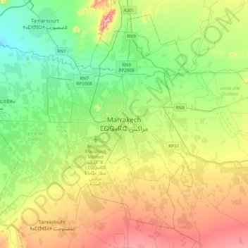
Name: Topografische Karte Marrakesh, Höhe, Relief.
Durchschnittliche Höhe: 485 m
Minimale Höhe: 347 m
Maximale Höhe: 739 m
Spenden
Rüste dich für dein nächstes Abenteuer:
Als Amazon-Partner verdient diese Website an qualifizierten Käufen, ohne zusätzliche Kosten für Sie.