
Topografische Karte Wolfstein
Interaktive Karte
Klicken Sie auf die Karte, um die Höhe anzuzeigen.
Über diese Karte
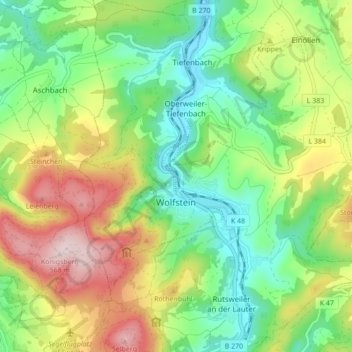
Name: Topografische Karte Wolfstein, Höhe, Relief.
Durchschnittliche Höhe: 327 m
Minimale Höhe: 178 m
Maximale Höhe: 568 m
The town lies in the North Palatine Uplands, in the so-called Königsland (“Kingsland”), between Idar-Oberstein and Kaiserslautern. The municipal area measures 1 377 ha, of which 644 ha is wooded. Also, 154 ha is given over to residential properties and transport facilities, 574 ha to agriculture and 5 ha is taken up by other uses and open water. Geographically, the municipal area belongs to the Glan-Alsenz mountain and hill country, which meets the Kaiserslauterer Senke (a depression) to the north. The town centre lies in the Lauter valley, cut narrowly into the land, between the steep slopes on either side of the Lauter, the Königsberg on the left bank and the Eisenknopf on the right. The Königsberg (not to be confused with the former East Prussian city) is the town's highest point at 568.4 m above sea level. Other selected elevations are as follows:
Andere topografische Karten
Klicken Sie auf eine Karte, um ihre Topografie, ihre Höhe und ihr Relief anzuzeigen.
Offenbach-Hundheim
Germany > Rhineland-Palatinate > Landkreis Kusel
Offenbach-Hundheim, Lauterecken-Wolfstein, Landkreis Kusel, Rhineland-Palatinate, 67749, Germany
Durchschnittliche Höhe: 250 m
Jettenbach
Germany > Rhineland-Palatinate > Landkreis Kusel > Jettenbach
Jettenbach, Lauterecken-Wolfstein, Landkreis Kusel, Rhineland-Palatinate, Germany
Durchschnittliche Höhe: 376 m
Hohenöllen
Germany > Rhineland-Palatinate > Landkreis Kusel
Hohenöllen, Lauterecken-Wolfstein, Landkreis Kusel, Rhineland-Palatinate, Germany
Durchschnittliche Höhe: 287 m