
Topografische Karte Epwell
Klicken Sie auf die Karte, um die Höhe anzuzeigen.
Über diese Karte
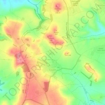
Name: Topografische Karte Epwell, Höhe, Relief.
Durchschnittliche Höhe: 181 m
Minimale Höhe: 130 m
Maximale Höhe: 229 m
Andere topografische Karten
Klicken Sie auf eine Karte, um ihre Topografie, ihre Höhe und ihr Relief anzuzeigen.
Great Bourton
United Kingdom > England > Oxfordshire > Cherwell District
Durchschnittliche Höhe: 118 m
Roman Meadow Banbury Country Park
United Kingdom > England > Oxfordshire > Cherwell District > Little Bourton
Durchschnittliche Höhe: 103 m
Stoke Lyne
United Kingdom > England > Oxfordshire > Cherwell District > Stoke Lyne
Durchschnittliche Höhe: 116 m
Shipton-on-Cherwell
United Kingdom > England > Oxfordshire > Cherwell District
Durchschnittliche Höhe: 78 m
Christmas Corner
United Kingdom > England > Oxfordshire > Cherwell District
Durchschnittliche Höhe: 168 m
Hampton Gay
United Kingdom > England > Oxfordshire > Cherwell District > Shipton-on-Cherwell
Durchschnittliche Höhe: 75 m
Little Chesterton
United Kingdom > England > Oxfordshire > Cherwell District > Wendlebury
Durchschnittliche Höhe: 72 m
Williamscot
United Kingdom > England > Oxfordshire > Cherwell District > Cropredy > Williamscot
Durchschnittliche Höhe: 118 m
Down End
United Kingdom > England > Oxfordshire > Cherwell District > Hook Norton
Durchschnittliche Höhe: 173 m
Nethercote
United Kingdom > England > Oxfordshire > Cherwell District > Banbury
Durchschnittliche Höhe: 111 m
Nethercote
United Kingdom > England > Oxfordshire > Cherwell District > Banbury
Durchschnittliche Höhe: 111 m
Great Bourton
United Kingdom > England > Oxfordshire > Cherwell District
Durchschnittliche Höhe: 118 m