
Spenden
Rüste dich für dein nächstes Abenteuer:
Als Amazon-Partner verdient diese Website an qualifizierten Käufen, ohne zusätzliche Kosten für Sie.
Topografische Karte Bilkhawthlir
Klicken Sie auf die Karte, um die Höhe anzuzeigen.
Spenden
Rüste dich für dein nächstes Abenteuer:
Als Amazon-Partner verdient diese Website an qualifizierten Käufen, ohne zusätzliche Kosten für Sie.
Über diese Karte
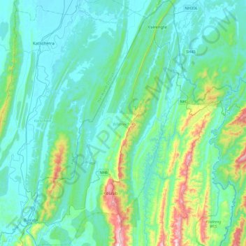
Name: Topografische Karte Bilkhawthlir, Höhe, Relief.
Ort: Bilkhawthlir, Kolasib, India (24.14080 92.52774 24.52313 92.89288)
Durchschnittliche Höhe: 158 m
Minimale Höhe: 22 m
Maximale Höhe: 813 m
Spenden
Rüste dich für dein nächstes Abenteuer:
Als Amazon-Partner verdient diese Website an qualifizierten Käufen, ohne zusätzliche Kosten für Sie.
Andere topografische Karten
Klicken Sie auf eine Karte, um ihre Topografie, ihre Höhe und ihr Relief anzuzeigen.
Maharashtra
Maharashtra is the third largest state by area in India. The Western Ghats better known as Sahyadri, are a hilly range running parallel to the coast, at an average elevation of 1,200 metres (4,000 ft). Kalsubai, a peak in the Sahyadris, near Nashik city is the highest elevated point in Maharashtra. To the west…
Durchschnittliche Höhe: 478 m
Spenden
Rüste dich für dein nächstes Abenteuer:
Als Amazon-Partner verdient diese Website an qualifizierten Käufen, ohne zusätzliche Kosten für Sie.
Guntur
India > Andhra Pradesh > Guntur
Guntur is located at 16°17′N 80°26′E / 16.29°N 80.43°E / 16.29; 80.43. It has an average elevation of 33 m (108 ft) and is situated on the plains. There are few hills in the surrounding suburban areas and Perecherla Reserve Forest on the north west. The city is around 64 km (40 mi) to the west…
Durchschnittliche Höhe: 29 m
Chennai
Chennai is located on the south–eastern coast of India in the north–eastern part of Tamil Nadu on a flat coastal plain known as the Eastern Coastal Plains. Its average elevation is around 6.7 metres (22 ft), and its highest point is 60 m (200 ft). Chennai is 2,184 kilometres (1,357 mi) south of Delhi,…
Durchschnittliche Höhe: 7 m
Spenden
Rüste dich für dein nächstes Abenteuer:
Als Amazon-Partner verdient diese Website an qualifizierten Käufen, ohne zusätzliche Kosten für Sie.
Guwahati
Professor Abani Kumar Bhagawati of Gauhati University stated that since before there were sufficient wetlands to absorb rainwater and channels to carry excess water to the Brahmaputra, the city did not experience floods. However, human interference has disrupted the natural topography, leading to the current…
Durchschnittliche Höhe: 113 m
Visakhapatnam
India > Andhra Pradesh > Visakhapatnam (Urban)
The city is situated between the Eastern Ghats and the Bay of Bengal. The city coordinates lies between 17.7041 N and 83.2977 E. The city's area is 682 km2. The average elevation is 45 metres. Visakhpatnam is situated in Coastal Andhra Region.
Durchschnittliche Höhe: 35 m
Spenden
Rüste dich für dein nächstes Abenteuer:
Als Amazon-Partner verdient diese Website an qualifizierten Käufen, ohne zusätzliche Kosten für Sie.
Mumbai
Mumbai lies at the mouth of the Ulhas River on the western coast of India, in the coastal region known as the Konkan. It sits on Salsette Island (Sashti Island), which it partially shares with the Thane district. Mumbai is bounded by the Arabian Sea to the west. Many parts of the city lie just above sea level,…
Durchschnittliche Höhe: 13 m
Spenden
Rüste dich für dein nächstes Abenteuer:
Als Amazon-Partner verdient diese Website an qualifizierten Käufen, ohne zusätzliche Kosten für Sie.
Spenden
Rüste dich für dein nächstes Abenteuer:
Als Amazon-Partner verdient diese Website an qualifizierten Käufen, ohne zusätzliche Kosten für Sie.
Spenden
Rüste dich für dein nächstes Abenteuer:
Als Amazon-Partner verdient diese Website an qualifizierten Käufen, ohne zusätzliche Kosten für Sie.
Spenden
Rüste dich für dein nächstes Abenteuer:
Als Amazon-Partner verdient diese Website an qualifizierten Käufen, ohne zusätzliche Kosten für Sie.
Ludhiana
India > Punjab > Ludhiana (West) Tahsil
Ludhiana is located at 30°54′N 75°51′E / 30.9°N 75.85°E / 30.9; 75.85. It has an average elevation of 244 metres (801 ft). Ludhiana City, to its residents, consists of the Old City and the New City. The new city primarily consists of the Civil Lines area which was historically known as the…
Durchschnittliche Höhe: 247 m
Spenden
Rüste dich für dein nächstes Abenteuer:
Als Amazon-Partner verdient diese Website an qualifizierten Käufen, ohne zusätzliche Kosten für Sie.
Spenden
Rüste dich für dein nächstes Abenteuer:
Als Amazon-Partner verdient diese Website an qualifizierten Käufen, ohne zusätzliche Kosten für Sie.
Udhagamandalam
India > Tamil Nadu > Udhagamandalam
Ooty is situated in the Nilgiri Biosphere Reserve. Many of the forested areas and water bodies are off-limits to most visitors in order to protect this fragile ecosystem. Some areas of the Biosphere Reserve have been earmarked for tourism development, and steps are being undertaken to open these areas to…
Durchschnittliche Höhe: 2.234 m
Lucknow
India > Uttar Pradesh > Lucknow
Lucknow stands at an elevation of approximately 123 metres (404 ft) above sea level. The city had an area of 402 km2 (155 square miles) until December 2019, when 88 villages were added to the municipal limits and the area increased to 631 km2 (244 square miles). Bounded on the east by Barabanki, on the west by…
Durchschnittliche Höhe: 120 m
Spenden
Rüste dich für dein nächstes Abenteuer:
Als Amazon-Partner verdient diese Website an qualifizierten Käufen, ohne zusätzliche Kosten für Sie.
Spenden
Rüste dich für dein nächstes Abenteuer:
Als Amazon-Partner verdient diese Website an qualifizierten Käufen, ohne zusätzliche Kosten für Sie.
Akluj
India > Maharashtra > Malshiras
Akluj is in Malshiras tehsil and is 120 km (75 mi) away from Solapur city. It is located on the right bank of Nira River. The elevation of Akluj is 551 m (1,808 ft). The latitude 17.9000 and longitude 75.0333. The altitude in feet 1581 Lat (DMS) north 17° 53' 60 N Long (DMS) east 75° 1' 60E altitude (meters)…
Durchschnittliche Höhe: 491 m
Spenden
Rüste dich für dein nächstes Abenteuer:
Als Amazon-Partner verdient diese Website an qualifizierten Käufen, ohne zusätzliche Kosten für Sie.
Spenden
Rüste dich für dein nächstes Abenteuer:
Als Amazon-Partner verdient diese Website an qualifizierten Käufen, ohne zusätzliche Kosten für Sie.
Spenden
Rüste dich für dein nächstes Abenteuer:
Als Amazon-Partner verdient diese Website an qualifizierten Käufen, ohne zusätzliche Kosten für Sie.
Mettupalayam
India > Tamil Nadu > Mettupalayam
Mettupalayam is located at 11°18′00″N 76°57′00″E / 11.3000°N 76.9500°E / 11.3000; 76.9500. It has an average elevation of 314 metres (1033 feet). Mettupalayam is situated on the bank of Bhavani River at the foot of the Nilgiri mountains.
Durchschnittliche Höhe: 321 m
Mangaluru
India > Karnataka > Mangaluru taluk
Mangalore is one of the fastest developing cities in India. The Dakshina Kannada district with its administrative headquarters at Mangalore has the highest Per Capita Income and Gross State Domestic Product in Karnataka, after Bangalore. Mangalore is a commercial, industrial, business, educational, healthcare,…
Durchschnittliche Höhe: 25 m
Spenden
Rüste dich für dein nächstes Abenteuer:
Als Amazon-Partner verdient diese Website an qualifizierten Käufen, ohne zusätzliche Kosten für Sie.
Kohima
India > Nagaland > Kohima Sadar
Kohima (/koʊˈhiːmə/ ; Angami Naga: Kewhira (IPA: [ˈkɛʍɪɻə]) is the capital of the Indian state of Nagaland. With a resident population of almost 100,000, it is the second largest city in the state. Kohima constitutes both a district and a municipality. The municipality covers 20 km2 (7.7 sq mi). The…
Durchschnittliche Höhe: 1.425 m
Digha
India > West Bengal > Digha
Digha is located at 21°38′18″N 87°30′35″E / 21.6384°N 87.5096°E / 21.6384; 87.5096. It has an average elevation of 6 metres (20 ft).
Durchschnittliche Höhe: 4 m
Spenden
Rüste dich für dein nächstes Abenteuer:
Als Amazon-Partner verdient diese Website an qualifizierten Käufen, ohne zusätzliche Kosten für Sie.
Lucknow
India > Uttar Pradesh > Lucknow
The city stands at an elevation of approximately 123 metres (404 ft) above sea level. Lucknow city had an area of 402 km2 (155 square miles) till December 2019, when 88 villages were added to the municipal limits and the area increased to 631 km2 (244 square miles). Bounded on the east by Barabanki, on the…
Durchschnittliche Höhe: 120 m
Kalaburagi
India > Karnataka > Kalaburagi taluku
The entire district is on the Deccan Plateau, and the elevation ranges from 300 to 750 m above MSL. Two main rivers, the Krishna and Bhima, flow through the district. The predominant soil type is black soil. The district has many tanks, which irrigate the land along with the river. The Upper Krishna Project is…
Durchschnittliche Höhe: 465 m
Mysuru
India > Karnataka > Mysuru taluk
Mysore (/maɪˈsɔːr/ (listen)), officially Mysuru ([ˈmaɪˈsuːɾu] (listen)), is a city in the southern part of the state of Karnataka, India. Mysore city is geographically located between 12° 18′ 26″ north latitude and 76° 38′ 59″ east longitude. It is located at an altitude of 770 m (2,530 ft)…
Durchschnittliche Höhe: 727 m
Angul
Angul (also known as Anugul) is a town and a municipality and the headquarters of Angul district in the state of Odisha, India. Angul has an average elevation of 195 m (640 ft) above sea level. The total geographical area of the district is 6232 km2. From the point of view of area, it stands 11th among the 30…
Durchschnittliche Höhe: 121 m
Spenden
Rüste dich für dein nächstes Abenteuer:
Als Amazon-Partner verdient diese Website an qualifizierten Käufen, ohne zusätzliche Kosten für Sie.
Rajamahendravaram
India > Andhra Pradesh > Rajahmundry (Urban)
Rajahmundry is located at 16°59′N 81°47′E / 16.98°N 81.78°E / 16.98; 81.78. with an average elevation of 14 metres (46 ft). It is geographically located at centre of Godavari Districts.There is paddy, sugarcane and various varieties of flowers cultivation in the area. River Godavari flows…
Durchschnittliche Höhe: 29 m
Navi Mumbai
India > Maharashtra > Thane > Navi Mumbai
Navi Mumbai (Marathi pronunciation: , also known by its former name New Bombay), is a planned city off the west coast of the Indian state of Maharashtra in Konkan division. The city is divided into two parts, North Navi Mumbai and South Navi Mumbai, for the individual development of Panvel Mega City, which…
Durchschnittliche Höhe: 30 m
Spenden
Rüste dich für dein nächstes Abenteuer:
Als Amazon-Partner verdient diese Website an qualifizierten Käufen, ohne zusätzliche Kosten für Sie.
Madikeri
India > Karnataka > Madikeri taluku
Madikeri features a tropical highland climate as it has an elevation of 1,170 m (3,840 ft). Madikeri is located at 12°25′N 75°44′E / 12.42°N 75.73°E / 12.42; 75.73. Madikeri lies in the Western Ghats and is a popular hill station. The nearest cities are Hassan to the north, Mangaluru to the…
Durchschnittliche Höhe: 1.054 m
Surat
India > Gujarat > Katargam Taluka > Surat
Surat is a port city situated on the banks of the Tapi river. Damming of the Tapi caused the original port facilities to close; the nearest port is now in the Magadalla and Hazira area of Surat Metropolitan Region.It has famous beach called 'Dumas Beach' located in Hazira. The city is located at 21°10′N…
Durchschnittliche Höhe: 11 m
Delhi
India > Delhi > Kotwali Tehsil
The topography of the medieval fort Purana Qila on the banks of the river Yamuna matches the literary description of the citadel Indraprastha in the Sanskrit epic Mahabharata; however, excavations in the area have revealed no signs of an ancient built environment. From the early 13th century until the mid-19th…
Durchschnittliche Höhe: 216 m
Spenden
Rüste dich für dein nächstes Abenteuer:
Als Amazon-Partner verdient diese Website an qualifizierten Käufen, ohne zusätzliche Kosten für Sie.
Bhopal
India > Madhya Pradesh > Huzur Tahsil
Bhopal has an average elevation of 500 metres (1401 ft) and is located in the central part of India, just north of the upper limit of the Vindhya mountain ranges. Located on the Malwa plateau, it is higher than the north Indian plains and the land rises towards the Vindhya Range to the south. The city has…
Durchschnittliche Höhe: 498 m
Spenden
Rüste dich für dein nächstes Abenteuer:
Als Amazon-Partner verdient diese Website an qualifizierten Käufen, ohne zusätzliche Kosten für Sie.
Spenden
Rüste dich für dein nächstes Abenteuer:
Als Amazon-Partner verdient diese Website an qualifizierten Käufen, ohne zusätzliche Kosten für Sie.
Spenden
Rüste dich für dein nächstes Abenteuer:
Als Amazon-Partner verdient diese Website an qualifizierten Käufen, ohne zusätzliche Kosten für Sie.
Spenden
Rüste dich für dein nächstes Abenteuer:
Als Amazon-Partner verdient diese Website an qualifizierten Käufen, ohne zusätzliche Kosten für Sie.
Spenden
Rüste dich für dein nächstes Abenteuer:
Als Amazon-Partner verdient diese Website an qualifizierten Käufen, ohne zusätzliche Kosten für Sie.
Spenden
Rüste dich für dein nächstes Abenteuer:
Als Amazon-Partner verdient diese Website an qualifizierten Käufen, ohne zusätzliche Kosten für Sie.