
Topografische Karte Cajicá
Interaktive Karte
Klicken Sie auf die Karte, um die Höhe anzuzeigen.
Cajicá
Cajicá is a municipality and town of Colombia in the department of Cundinamarca, 39 km (24 mi) north of the capital Bogotá. It is located in the Central Savanna Province, being the third most populous municipality in the province after Zipaquirá and Chía. It is bordered by the municipalities of Zipaquirá to the north, Sopó to the east, Chía to the south, and Tabio to the west. The town is located at an altitude of 2,558 metres (8,392 ft) and has an average temperature of 14 °C (57 °F).
Über diese Karte
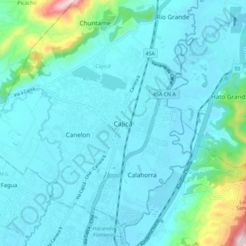
Name: Topografische Karte Cajicá, Höhe, Relief.
Durchschnittliche Höhe: 2.611 m
Minimale Höhe: 2.541 m
Maximale Höhe: 3.104 m