
Topografische Karte Bihar
Klicken Sie auf die Karte, um die Höhe anzuzeigen.
Bihar
Bihar covers a total area of 94,163 km2 (36,357 sq mi), with an average elevation above sea level of 173 feet (53 m). It is land locked by Nepal in the north, Jharkhand in the south West Bengal in the east and Uttar Pradesh to the west. It has three parts on the basis of physical and structural conditions: the Southern Plateau, the Shivalik Region, and Bihar's Gangetic Plain. Furthermore, the vast stretch of fertile Bihar Plain is divided by the Ganges River into two unequal parts – North Bihar and South Bihar. The Ganges flows west–east and, along with its tributaries, regularly floods parts of the Bihar plain. The main northern tributaries are the Gandak and Koshi, which originate in the Nepalese Himalayas, and the Bagmati, which originates in the Kathmandu Valley. Other tributaries are the Son, Budhi Gandak, Chandan, Orhani and Phalgu. Bihar has some small hills, such as the Rajgir hills in center, Kaimur Range in south-west and Shivalik Range in North. Bihar has notified forest area of 6,764.14 km2, which is 7.1 percent of its geographical area. The sub-Himalayan foothills of Shivalik ranges, primary Someshwar and Dun mountain, in West Champaran district are clad in a belt of moist deciduous forest. As well as trees, this consists of scrub, grass and reeds.
Über diese Karte
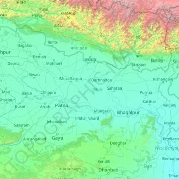
Name: Topografische Karte Bihar, Höhe, Relief.
Ort: Bihar, India (24.28572 83.32126 27.52164 88.29380)
Durchschnittliche Höhe: 605 m
Minimale Höhe: 12 m
Maximale Höhe: 8.114 m
Andere topografische Karten
Klicken Sie auf eine Karte, um ihre Topografie, ihre Höhe und ihr Relief anzuzeigen.
Maharashtra
Maharashtra is the third largest state by area in India. The Western Ghats better known as Sahyadri, are a hilly range running parallel to the coast, at an average elevation of 1,200 metres (4,000 ft). Kalsubai, a peak in the Sahyadris, near Nashik city is the highest elevated point in Maharashtra. To the west…
Durchschnittliche Höhe: 478 m
Guwahati
Professor Abani Kumar Bhagawati of Gauhati University stated that since before there were sufficient wetlands to absorb rainwater and channels to carry excess water to the Brahmaputra, the city did not experience floods. However, human interference has disrupted the natural topography, leading to the current…
Durchschnittliche Höhe: 113 m
Thiruvananthapuram
India > Kerala > Thiruvananthapuram
Thiruvananthapuram is built on seven hills by the seashore and is at 8°30′N 76°54′E / 8.5°N 76.9°E / 8.5; 76.9 on the west coast, near the southern tip of mainland India. The city is on the west coast of India and is bounded by the Laccadive Sea to its west and the Western Ghats to its east.…
Durchschnittliche Höhe: 33 m
Dehradun
India > Uttarakhand > Dehradun
The city of Dehradun mainly lies in Doon Valley and is at a varying height from 410 m (1,350 ft) in Clement Town to above 700 m (2,300 ft) at Malsi which is 15 km (9.3 mi) from the city. However, the average elevation is 450 m (1,480 ft) above sea level. Malsi is the starting point of Lesser Himalayan Range…
Durchschnittliche Höhe: 904 m
Chennai
Chennai is located on the south–eastern coast of India in the north–eastern part of Tamil Nadu on a flat coastal plain known as the Eastern Coastal Plains. Its average elevation is around 6.7 metres (22 ft), and its highest point is 60 m (200 ft). Chennai is 2,184 kilometres (1,357 mi) south of Delhi,…
Durchschnittliche Höhe: 7 m
Kolhapur
India > Maharashtra > Karvir
Kolhapur is an inland city located in south-west Maharashtra state, 373 km (232 mi) south of Mumbai and 228 km (142 mi) south of Pune, 615 km (382 mi) north-west of Bengaluru and 530 km (330 mi) west of Hyderabad. Within Maharashtra, Kolhapur's nearest cities and towns are Ichalkaranji 27 km (17 mi), Kodoli 35…
Durchschnittliche Höhe: 592 m
Western Ghats
The range starts near south of the Tapti river and runs approximately 1,600 km (990 mi) through the states of Gujarat, Maharashtra, Karnataka, Goa, Kerala and Tamil Nadu ending at Marunthuvazh Malai, Swamithope near the southern tip of India. These hills cover 160,000 km2 (62,000 sq mi) and form the catchment…
Durchschnittliche Höhe: 2.225 m
Navi Mumbai
India > Maharashtra > Thane > Navi Mumbai
Navi Mumbai (Marathi pronunciation: , also known by its former name New Bombay), is a planned city off the west coast of the Indian state of Maharashtra in Konkan division. The city is divided into two parts, North Navi Mumbai and South Navi Mumbai, for the individual development of Panvel Mega City, which…
Durchschnittliche Höhe: 30 m
Surat
India > Gujarat > Katargam Taluka > Surat
Surat is a port city situated on the banks of the Tapi river. Damming of the Tapi caused the original port facilities to close; the nearest port is now in the Magadalla and Hazira area of Surat Metropolitan Region.It has famous beach called 'Dumas Beach' located in Hazira. The city is located at 21°10′N…
Durchschnittliche Höhe: 11 m
Secunderabad
Situated in the North of Hyderabad at 17°27′N 78°30′E / 17.45°N 78.5°E / 17.45; 78.5., Secunderabad lies on the northern part of the Deccan Plateau. Secunderabad has an average elevation of 543 metres (1781 ft). Most of the area has a rocky terrain and some areas are hilly.
Durchschnittliche Höhe: 544 m
Mumbai
Mumbai lies at the mouth of the Ulhas River on the western coast of India, in the coastal region known as the Konkan. It sits on Salsette Island (Sashti Island), which it partially shares with the Thane district. Mumbai is bounded by the Arabian Sea to the west. Many parts of the city lie just above sea level,…
Durchschnittliche Höhe: 13 m
Kunigal
India > Karnataka > Kunigal taluk
Kunigal is located at 13°01′N 77°02′E / 13.02°N 77.03°E / 13.02; 77.03. It has an average elevation of 773 metres (2536 feet). It is situated on the National Highway 75 (India) connecting Bengaluru and Mangaluru and State Highway 33 (Karnataka) connecting Tumakuru and Madduru. Kunigal is…
Durchschnittliche Höhe: 775 m
Alandi
India > Maharashtra > Khed
Alandi (18°40′37.42″N 73°53′47.76″E / 18.6770611°N 73.8966000°E / 18.6770611; 73.8966000) is located on the bank of the Indrayani River, 18.8 km (11.7 mi) from Khed Taluka of Pune District, near the northern edge of the city of Pune. Alandi has an average elevation of 577 meters (1,893 feet).
Durchschnittliche Höhe: 578 m
Digha
India > West Bengal > Digha
Digha is located at 21°38′18″N 87°30′35″E / 21.6384°N 87.5096°E / 21.6384; 87.5096. It has an average elevation of 6 metres (20 ft).
Durchschnittliche Höhe: 4 m
Salem
Salem is located at 11°40′N 78°08′E / 11.67°N 78.14°E / 11.67; 78.14, at an average elevation of 278 m (912 ft). The city is surrounded by hills: Nagaramalai on the north, Jarugumalai on the south, Kanjamalai on the west, Godumalai on the east and the Shevaroy Hills on the northeast.…
Durchschnittliche Höhe: 418 m
Mangalagiri
India > Andhra Pradesh > Mangalagiri
Mangalagiri is located at 16°26′N 80°33′E / 16.43°N 80.55°E / 16.43; 80.55. It has an average elevation of 29.08 m (95.4 ft).It is located 22 kilometres (14 mi) north east of the district headquarters, Guntur, and just 15 km (9.3 mi) south west of Vijayawada and also 30 km (19 mi) to the north…
Durchschnittliche Höhe: 29 m
Dombivli
India > Maharashtra > Kalyan Subdistrict > Kalyan-Dombivli
Dombivli is located at 19°13′06″N 73°05′12″E / 19.218433°N 73.086718°E / 19.218433; 73.086718. It has an average elevation of 13.534 meters (44.403 feet). The land here is rough and rocky by nature. The Ulhas river flows from its north.
Durchschnittliche Höhe: 11 m
Dwarka
India > Gujarat > Okhamandal Taluka
Considered a holy city, Dwarka is well known for its temples and as a pilgrimage centre for Hindus. The Dwarakadhisa Temple, also called Jagat Mandir, located in the heart of Dwarka, is a Vaishnava temple. It was built by Raja Jagat Singh Rathore, hence it is called Jagat Mandir. The temple, facing west, is at…
Durchschnittliche Höhe: 3 m
Kannur
India > Kerala > Kannur > Kannur
Kannur has an elevation of 1.02 metres or 3.3 feet along the coast of the Laccadive Sea, with a sandy coastal area. The city has an 8 kilometres (5.0 mi)-long seashore and a 3 kilometres (1.9 mi)-long beach at Payyambalam. Kannur is located north of Kozhikode, south of Kasargod and Mangalore, west of the…
Durchschnittliche Höhe: 13 m
Shimla
Shimla is on the south-western ranges of the Himalayas at 31°37′N 77°06′E / 31.61°N 77.10°E / 31.61; 77.10. It has an average altitude of 2,206 metres (7,238 ft) above mean sea level and extends along a ridge with seven spurs. The city stretches nearly 9.2 kilometres (5.7 mi) from east to west.
Durchschnittliche Höhe: 1.557 m
Gwalior
India > Madhya Pradesh > Gird Tahsil
Gwalior is located at 26°13′N 78°11′E / 26.22°N 78.18°E / 26.22; 78.18. in northern Madhya Pradesh 300 km (186 miles) from Delhi. It has an average elevation of 197 metres (646 feet). Most part of it comes under the Bundelkhand area.
Durchschnittliche Höhe: 235 m
Kothagudem
India > Telangana > Kothagudem mandal
Kothagudem is located at 17°33′00″N 80°37′05″E / 17.55°N 80.618°E / 17.55; 80.618. It has an average elevation of 89 metres (295 ft) above sea level. The North of Kothagudem borders Chhattisgarh state which is approximately 120 km from the town.
Durchschnittliche Höhe: 109 m
Vadodara
India > Gujarat > Vadodara Rural Taluka
Vadodara is located at 22°18′N 73°11′E / 22.30°N 73.19°E / 22.30; 73.19 in western India at an elevation of 39 metres (128 ft). It is the tenth-largest city in India with an area of 400 square kilometres (150 sq mi) and a population of 3.5 million, according to the 2010–11 census. The city…
Durchschnittliche Höhe: 36 m
Cumbum
India > Tamil Nadu > Uthamapalayam
Cumbum is located at 9°44′N 77°18′E / 9.73°N 77.3°E / 9.73; 77.3. It has an average elevation of 391meters (1282 feet). One can see the backdrop of Kodaikanal Hills from Cumbum. Apart from that Cumbum has most vigorous activity in agriculture.
Durchschnittliche Höhe: 432 m
Chandigarh
India > Chandigarh > Chandigarh
Chandigarh is located by the foothills of the Shivalik Range of the Himalayas in northwest India. It covers an area of approximately 114 km2. It borders the states of Punjab and Haryana. The exact geographic coordinates of Chandigarh are 30°44′N 76°47′E / 30.74°N 76.79°E / 30.74; 76.79. It has…
Durchschnittliche Höhe: 378 m
Ayodhya
India > Uttar Pradesh > Faizabad
The earliest of the Buddhist Pali-language texts and the Jain Prakrit-language texts mention a city called Saketa (Sageya or Saeya in Prakrit) as an important city of the Kosala mahajanapada. Topographical indications in both Buddhist and Jain texts suggest that Saketa is the same as the present-day Ayodhya.…
Durchschnittliche Höhe: 96 m