
Spenden
Rüste dich für dein nächstes Abenteuer:
Als Amazon-Partner verdient diese Website an qualifizierten Käufen, ohne zusätzliche Kosten für Sie.
Topografische Karte Triple Divide Peak
Klicken Sie auf die Karte, um die Höhe anzuzeigen.
Spenden
Rüste dich für dein nächstes Abenteuer:
Als Amazon-Partner verdient diese Website an qualifizierten Käufen, ohne zusätzliche Kosten für Sie.
Über diese Karte
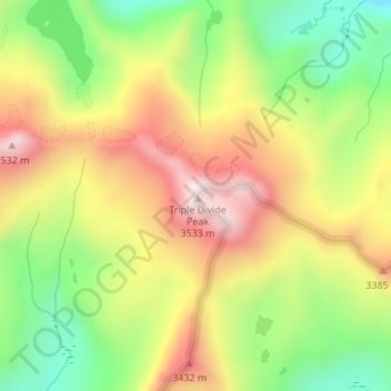
Name: Topografische Karte Triple Divide Peak, Höhe, Relief.
Durchschnittliche Höhe: 3.209 m
Minimale Höhe: 2.900 m
Maximale Höhe: 3.535 m
Spenden
Rüste dich für dein nächstes Abenteuer:
Als Amazon-Partner verdient diese Website an qualifizierten Käufen, ohne zusätzliche Kosten für Sie.
Andere topografische Karten
Klicken Sie auf eine Karte, um ihre Topografie, ihre Höhe und ihr Relief anzuzeigen.
Oakhurst
United States > California > Madera County > Oakhurst
Oakhurst is located on the Fresno River 3 miles (5 km) south-southwest of Yosemite Forks, at an elevation of 2,274 feet (693 m). Its coordinates are 37°19′41″N 119°38′58″W / 37.32806°N 119.64944°W / 37.32806; -119.64944. It is located at the junction of state highways 41 and 49, at the…
Durchschnittliche Höhe: 837 m
Ansel Adams Wilderness
United States > California > Madera County
The Ansel Adams wilderness spans in elevation from 3,500 to 13,157 feet (1,067 to 4,010 m), forming the northern end of the High Sierra.
Durchschnittliche Höhe: 2.506 m
Spenden
Rüste dich für dein nächstes Abenteuer:
Als Amazon-Partner verdient diese Website an qualifizierten Käufen, ohne zusätzliche Kosten für Sie.
Oakhurst
United States > California > Madera County > Oakhurst
Oakhurst is located on the Fresno River 3 miles (5 km) south-southwest of Yosemite Forks, at an elevation of 2,274 feet (693 m). Its coordinates are 37°19′41″N 119°38′58″W / 37.32806°N 119.64944°W / 37.32806; -119.64944. It is located at the junction of state highways 41 and 49, at the…
Durchschnittliche Höhe: 837 m
Oakhurst
United States > California > Madera County > Oakhurst
Oakhurst (formerly Fresno Flats) is a census-designated place (CDP) in Madera County, California, United States, 14 miles (23 km) south of the entrance to Yosemite National Park, in the foothills of the Sierra Nevada. At an elevation of 2,274 ft (693 m), Oakhurst is situated at the junction of Highway 41 and…
Durchschnittliche Höhe: 837 m
Spenden
Rüste dich für dein nächstes Abenteuer:
Als Amazon-Partner verdient diese Website an qualifizierten Käufen, ohne zusätzliche Kosten für Sie.
Oakhurst
United States > California > Madera County > Oakhurst
Oakhurst (formerly Fresno Flats) is a census-designated place (CDP) in Madera County, California, United States, 14 miles (23 km) south of the entrance to Yosemite National Park, in the foothills of the Sierra Nevada. At an elevation of 2,274 ft (693 m), Oakhurst is situated at the junction of Highway 41 and…
Durchschnittliche Höhe: 837 m
Chowchilla
United States > California > Madera County
Chowchilla is a city in Madera County, California, United States. The city's population was 19,039 at the 2020 census. Chowchilla is located 16 miles (26 km) northwest of Madera, at an elevation of 240 feet (73 m).
Durchschnittliche Höhe: 70 m
Spenden
Rüste dich für dein nächstes Abenteuer:
Als Amazon-Partner verdient diese Website an qualifizierten Käufen, ohne zusätzliche Kosten für Sie.