
Topografische Karte Adimali
Interaktive Karte
Klicken Sie auf die Karte, um die Höhe anzuzeigen.
Über diese Karte
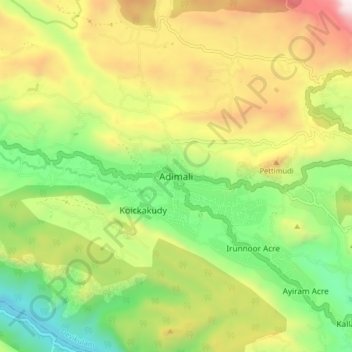
Name: Topografische Karte Adimali, Höhe, Relief.
Ort: Adimali, Devikulam, Idukki District, Kerala, 685561, India (9.97443 76.91546 10.05443 76.99546)
Durchschnittliche Höhe: 786 m
Minimale Höhe: 177 m
Maximale Höhe: 1.633 m
Adimaly generally has a cool climate throughout the year, typical of the higher altitudes, though not as cold as Munnar. Temperatures rarely exceed 26 degrees and never drop below 10 degrees as it usually stays around 17-24 degrees. Though December–January are comparatively cooler than other months. Adimaly is a place with heavy rainfall mostly throughout the year and it is heaviest during the June–September season of southwest monsoon. Rains in Adimaly sometimes continue for hours or even days without any dry spell, which may bring the town to a standstill. New residents frequently relocate to Adimaly, owing to its atmosphere and surroundings. This is evident considering the abrupt increase in population both within the town and nearby areas in the recent past.
Andere topografische Karten
Klicken Sie auf eine Karte, um ihre Topografie, ihre Höhe und ihr Relief anzuzeigen.
Munnar Town
India > Kerala > Devikulam > Munnar
Munnar Town, Munnar, Devikulam, Idukki District, Kerala, 685612, India
Durchschnittliche Höhe: 1.587 m
Chithirapuram
Chithirapuram, Devikulam, Idukki District, Kerala, 685565, India
Durchschnittliche Höhe: 1.063 m
Pallivasal
Pallivasal, Devikulam, Idukki District, Kerala, 685565, India
Durchschnittliche Höhe: 1.305 m