
Topografische Karte Braunlage
Interaktive Karte
Klicken Sie auf die Karte, um die Höhe anzuzeigen.
Über diese Karte
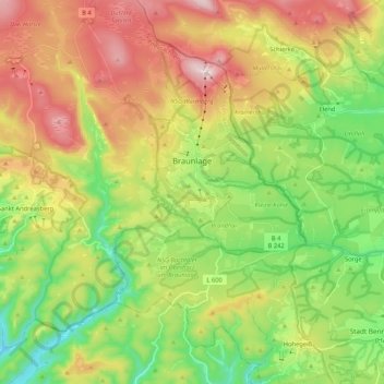
Name: Topografische Karte Braunlage, Höhe, Relief.
Ort: Braunlage, Landkreis Goslar, Lower Saxony, Germany (51.65043 10.49042 51.78087 10.68399)
Durchschnittliche Höhe: 617 m
Minimale Höhe: 365 m
Maximale Höhe: 967 m
Braunlage is located on the Warme Bode, a headstream of the river Bode, close to the border with Elend in the state of Saxony-Anhalt. The municipal area stretches along the south-eastern rim of the Harz National Park from an elevation of 550 m (1,800 ft) up to 971 m (3,186 ft) at the summit of the Wurmberg. Other peaks in the vicinity include the Achtermannshöhe and the Hahnenklee Crags.
Andere topografische Karten
Klicken Sie auf eine Karte, um ihre Topografie, ihre Höhe und ihr Relief anzuzeigen.
Hohegeiß
Germany > Lower Saxony > Landkreis Goslar > Braunlage
Hohegeiß, Braunlage, Landkreis Goslar, Lower Saxony, Germany
Durchschnittliche Höhe: 568 m
Sankt Andreasberg
Germany > Lower Saxony > Landkreis Goslar > Braunlage
Sankt Andreasberg, Braunlage, Landkreis Goslar, Lower Saxony, Germany
Durchschnittliche Höhe: 648 m
Altenau
Germany > Lower Saxony > Landkreis Goslar > Clausthal-Zellerfeld
Altenau, Altenau - Schulenberg i.O., Clausthal-Zellerfeld, Landkreis Goslar, Lower Saxony, Germany
Durchschnittliche Höhe: 599 m
Lochtum
Germany > Lower Saxony > Landkreis Goslar > Goslar
Lochtum, Goslar, Landkreis Goslar, Lower Saxony, Germany
Durchschnittliche Höhe: 196 m
Langelsheim (Innenstadt)
Germany > Lower Saxony > Landkreis Goslar > Langelsheim (Innenstadt)
Langelsheim (Innenstadt), Langelsheim, Landkreis Goslar, Lower Saxony, 38685, Germany
Durchschnittliche Höhe: 257 m
Clausthal-Zellerfeld
Germany > Lower Saxony > Landkreis Goslar
Clausthal-Zellerfeld, Landkreis Goslar, Lower Saxony, Germany
Durchschnittliche Höhe: 466 m