
Topografische Karte Covelo
Interaktive Karte
Klicken Sie auf die Karte, um die Höhe anzuzeigen.
Über diese Karte
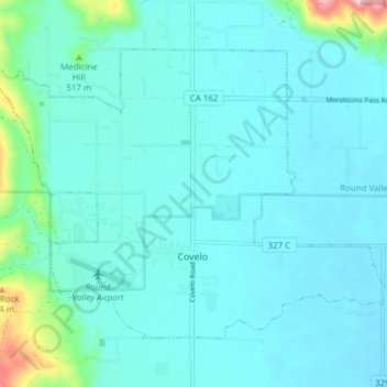
Name: Topografische Karte Covelo, Höhe, Relief.
Ort: Covelo, Mendocino County, California, 95428, United States (39.78042 -123.28683 39.82439 -123.21033)
Durchschnittliche Höhe: 440 m
Minimale Höhe: 407 m
Maximale Höhe: 673 m
Covelo (/ˈkoʊvəloʊ/ KOH-və-loh) is a census-designated place (CDP) in Mendocino County, California, United States. Covelo is located 14 miles (23 km) east-northeast of Laytonville, at an elevation of 1,398 feet (426 m). The population was 1,394 at the 2020 census, up from 1,255 at the 2010 census. 405 acres (1.64 km2) of Covelo is part of the Round Valley Indian Reservation.