
Topografische Karte Burnley
Interaktive Karte
Klicken Sie auf die Karte, um die Höhe anzuzeigen.
Über diese Karte
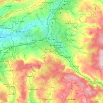
Name: Topografische Karte Burnley, Höhe, Relief.
Ort: Burnley, Lancashire, England, United Kingdom (53.72300 -2.34231 53.82526 -2.11228)
Durchschnittliche Höhe: 247 m
Minimale Höhe: 63 m
Maximale Höhe: 479 m
The town lies in a natural three-forked valley at the confluence of the River Brun and the River Calder, surrounded by open fields, with wild moorland at higher altitudes. To the west of Burnley lie the towns of Padiham, Accrington and Blackburn, with Nelson and Colne to the north. The centre of the town stands at approximately 387 feet (118 m) above sea level and 30 miles (48 km) east of the Irish Sea coast.
Andere topografische Karten
Klicken Sie auf eine Karte, um ihre Topografie, ihre Höhe und ihr Relief anzuzeigen.
Waddington
United Kingdom > England > Lancashire > Ribble Valley
Waddington, Ribble Valley, Lancashire, England, United Kingdom
Durchschnittliche Höhe: 164 m
Great Eccleston
United Kingdom > England > Lancashire > Borough of Wyre
Great Eccleston, Borough of Wyre, Lancashire, England, United Kingdom
Durchschnittliche Höhe: 12 m
Wymott
United Kingdom > England > Lancashire > Chorley
Wymott, Ulnes Walton, Chorley, Lancashire, England, PR26 8NH, United Kingdom
Durchschnittliche Höhe: 17 m
Croston
United Kingdom > England > Lancashire > Chorley
Croston, Chorley, Lancashire, England, United Kingdom
Durchschnittliche Höhe: 8 m
Fleetwood
United Kingdom > England > Lancashire > Borough of Wyre
Fleetwood, Borough of Wyre, Lancashire, England, United Kingdom
Durchschnittliche Höhe: 2 m
Leyland
United Kingdom > England > Lancashire > South Ribble
Leyland, South Ribble, Lancashire, England, PR25 2EX, United Kingdom
Durchschnittliche Höhe: 41 m
Read
United Kingdom > England > Lancashire > Ribble Valley
Read, Ribble Valley, Lancashire, England, United Kingdom
Durchschnittliche Höhe: 114 m
Lytham St Annes
United Kingdom > England > Lancashire > Fylde > Lytham St Annes
Lytham St Annes, Fylde, Lancashire, North West England, England, FY8 4AR, United Kingdom
Durchschnittliche Höhe: 5 m
Jamacia Wood
United Kingdom > England > Lancashire > Ribble Valley > Langho
Jamacia Wood, Billington and Langho, Langho, Ribble Valley, Lancashire, England, United Kingdom
Durchschnittliche Höhe: 100 m