
Topografische Karte Carl
Interaktive Karte
Klicken Sie auf die Karte, um die Höhe anzuzeigen.
Über diese Karte
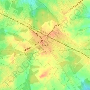
Name: Topografische Karte Carl, Höhe, Relief.
Ort: Carl, Barrow County, Georgia, United States (33.99121 -83.82909 34.01609 -83.80222)
Durchschnittliche Höhe: 317 m
Minimale Höhe: 292 m
Maximale Höhe: 333 m
Andere topografische Karten
Klicken Sie auf eine Karte, um ihre Topografie, ihre Höhe und ihr Relief anzuzeigen.
Fort Yargo State Park
United States > Georgia > Barrow County > Winder
Fort Yargo State Park, Winder, Barrow County, Georgia, United States
Durchschnittliche Höhe: 270 m
Auburn
United States > Georgia > Barrow County
Auburn, Barrow County, Georgia, 30011, United States
Durchschnittliche Höhe: 300 m
Statham
United States > Georgia > Barrow County
Statham, Barrow County, Georgia, United States
Durchschnittliche Höhe: 261 m
Russell
United States > Georgia > Barrow County
Russell, Barrow County, Georgia, 30680, United States
Durchschnittliche Höhe: 279 m
Bethlehem
United States > Georgia > Barrow County
Bethlehem, Barrow County, Georgia, United States
Durchschnittliche Höhe: 258 m
Winder
United States > Georgia > Barrow County
Winder, Barrow County, Georgia, United States
Durchschnittliche Höhe: 274 m