
Topografische Karte Eureka Springs
Interaktive Karte
Klicken Sie auf die Karte, um die Höhe anzuzeigen.
Über diese Karte
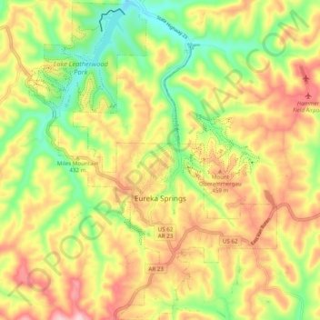
Name: Topografische Karte Eureka Springs, Höhe, Relief.
Durchschnittliche Höhe: 411 m
Minimale Höhe: 300 m
Maximale Höhe: 525 m
It is a tourist destination for its unique character as a Victorian resort, which first attracted visitors to use its then believed healing springs. The city has steep winding streets filled with Victorian-style cottages and manors. The historic commercial downtown of the city has an extensive streetscape of well-preserved Victorian buildings. The buildings are primarily constructed of local stone, built along limestone streets that curve around the hills, and rise and fall with the topography in a five-mile long loop. Some buildings have street-level entrances on more than one floor and other such oddities: the Basin Park Hotel has its front entrances on the floor below first, and a ground-level emergency exit in the back of the building on the fifth floor. The streets wind around the town, with few intersecting at right angles. There are no traffic lights.
Andere topografische Karten
Klicken Sie auf eine Karte, um ihre Topografie, ihre Höhe und ihr Relief anzuzeigen.
Osage
United States > Arkansas > Carroll County
Osage, Carroll County, Arkansas, United States
Durchschnittliche Höhe: 465 m
Eureka Springs
United States > Arkansas > Carroll County > Eureka Springs
Eureka Springs, Carroll County, Arkansas, 72632, United States
Durchschnittliche Höhe: 417 m
Table Rock Lake
United States > Arkansas > Carroll County > Kimberling City
Table Rock Lake, Kimberling City, Carroll County, Arkansas, United States
Durchschnittliche Höhe: 333 m