
Topografische Karte Apaseo el Grande
Interaktive Karte
Klicken Sie auf die Karte, um die Höhe anzuzeigen.
Über diese Karte
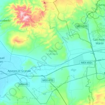
Name: Topografische Karte Apaseo el Grande, Höhe, Relief.
Ort: Apaseo el Grande, Guanajuato, Mexico (20.46445 -100.76486 20.71827 -100.48209)
Durchschnittliche Höhe: 1.911 m
Minimale Höhe: 1.759 m
Maximale Höhe: 2.596 m
Andere topografische Karten
Klicken Sie auf eine Karte, um ihre Topografie, ihre Höhe und ihr Relief anzuzeigen.
Guanajuato City
Mexico > Guanajuato > Municipio de Guanajuato
Although only one out of every 100 bodies interred in the cemetery became naturally mummified, the concentration of this phenomenon has led to theories about how they have come about. Some believe that they are the result of people who had been buried alive, after mistakenly declared dead. These people,…
Durchschnittliche Höhe: 2.182 m
San Miguel de Allende
Mexico > Guanajuato > San Miguel de Allende > San Miguel de Allende
Durchschnittliche Höhe: 2.029 m
Dolores Hidalgo
Mexico > Guanajuato > Dolores Hidalgo
It is located at 21°10′N 100°56′W / 21.17°N 100.93°W / 21.17; -100.93, at an elevation of about 1,980 meters (6,500 feet) above sea level. In the census of 2005 the city had a population of 54,843, while the municipality had 134,641 inhabitants. The city lies directly in the center of the…
Durchschnittliche Höhe: 1.938 m
Silao
Mexico > Guanajuato > Silao de la Victoria
Silao is located in the Mexican state of Guanajuato. It is situated 100° 25´ 59´´ longitude west of the Greenwich meridian and 20° 56' 24 latitude north. Its altitude is 1,780 meters above sea level.
Durchschnittliche Höhe: 1.877 m
Irapuato
Mexico > Guanajuato > Irapuato
It has a humid subtropical climate (Cwa in the Köppen climate classification) with an average temperature of 20 °C (68 °F). The large majority of rainfall occurs from June - September. It is at an altitude above sea level of 1,724 meters (5,656 ft).
Durchschnittliche Höhe: 1.763 m
San Antionio Espinoza
Mexico > Guanajuato > Presa Blanca > San Antionio Espinoza
Durchschnittliche Höhe: 1.802 m
Irapuato
Mexico > Guanajuato > Irapuato
It has a humid subtropical climate (Cwa in the Köppen climate classification) with an average temperature of 20 °C (68 °F). The large majority of rainfall occurs from June - September. It is at an altitude above sea level of 1,724 meters (5,656 ft).
Durchschnittliche Höhe: 1.763 m