
Topografische Karte Hudson
Interaktive Karte
Klicken Sie auf die Karte, um die Höhe anzuzeigen.
Über diese Karte
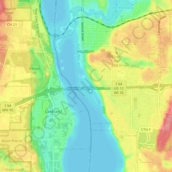
Name: Topografische Karte Hudson, Höhe, Relief.
Ort: Hudson, Saint Croix County, Wisconsin, 54016, United States (44.93794 -92.77081 44.98918 -92.68940)
Durchschnittliche Höhe: 243 m
Minimale Höhe: 204 m
Maximale Höhe: 302 m
Andere topografische Karten
Klicken Sie auf eine Karte, um ihre Topografie, ihre Höhe und ihr Relief anzuzeigen.
Mount Hellen
United States > Wisconsin > Saint Croix County > Town of Saint Joseph
Mount Hellen, Town of Saint Joseph, Saint Croix County, Wisconsin, United States
Durchschnittliche Höhe: 282 m
Village of Hammond
United States > Wisconsin > Saint Croix County
Village of Hammond, Saint Croix County, Wisconsin, United States
Durchschnittliche Höhe: 342 m
Somerset
United States > Wisconsin > Saint Croix County > Somerset
Somerset, Saint Croix County, Wisconsin, 54025, United States
Durchschnittliche Höhe: 273 m
Baldwin
United States > Wisconsin > Saint Croix County > Baldwin
Baldwin, Saint Croix County, Wisconsin, 54002, United States
Durchschnittliche Höhe: 350 m
Town of Somerset
United States > Wisconsin > Saint Croix County
Town of Somerset, Saint Croix County, Wisconsin, United States
Durchschnittliche Höhe: 279 m
Town of Hudson
United States > Wisconsin > Saint Croix County
Town of Hudson, Saint Croix County, Wisconsin, United States
Durchschnittliche Höhe: 281 m
New Richmond
United States > Wisconsin > Saint Croix County
New Richmond, Saint Croix County, Wisconsin, 54017, United States
Durchschnittliche Höhe: 303 m
Roberts
United States > Wisconsin > Saint Croix County
Roberts, Saint Croix County, Wisconsin, United States
Durchschnittliche Höhe: 313 m
North Hudson
United States > Wisconsin > Saint Croix County
North Hudson, Saint Croix County, Wisconsin, United States
Durchschnittliche Höhe: 230 m