
Topografische Karte Fairview
Interaktive Karte
Klicken Sie auf die Karte, um die Höhe anzuzeigen.
Über diese Karte
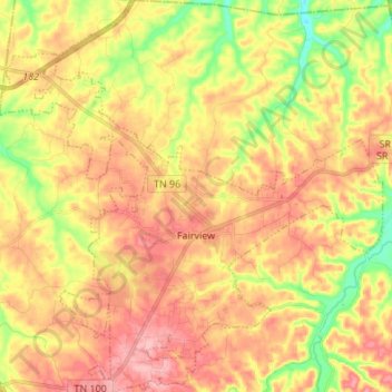
Name: Topografische Karte Fairview, Höhe, Relief.
Ort: Fairview, Williamson County, Tennessee, 37062, United States (35.93807 -87.18969 36.04810 -87.05648)
Durchschnittliche Höhe: 233 m
Minimale Höhe: 164 m
Maximale Höhe: 287 m
Fairview was incorporated on July 28, 1959, under the Uniform City Manager-Commission Charter as set out in the Tennessee Code Annotated. Fairview city limits are located about one mile (1.6 km) southwest from the Nashville-Davidson County line and has two interstates passing through it (I-40 & I-840). With an average elevation of 800 feet (240 m) above sea level, Fairview is about 150 feet (46 m) higher than Nashville and surrounding suburbs, which gives Fairview the advantage of being less flood prone.