
Topografische Karte Fayette County
Interaktive Karte
Klicken Sie auf die Karte, um die Höhe anzuzeigen.
Über diese Karte
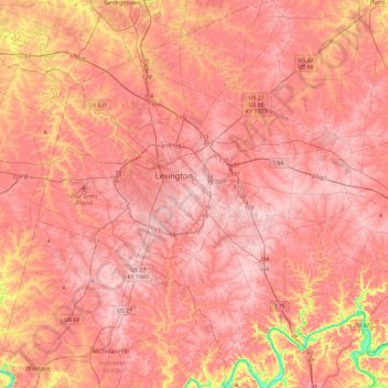
Name: Topografische Karte Fayette County, Höhe, Relief.
Ort: Fayette County, Kentucky, United States (37.84530 -84.66042 38.21140 -84.28272)
Durchschnittliche Höhe: 282 m
Minimale Höhe: 163 m
Maximale Höhe: 326 m
Andere topografische Karten
Klicken Sie auf eine Karte, um ihre Topografie, ihre Höhe und ihr Relief anzuzeigen.
Paducah
United States > Kentucky > McCracken County
Paducah, McCracken County, Kentucky, United States
Durchschnittliche Höhe: 108 m
Louisville
United States > Kentucky > Jefferson County
Louisville, Jefferson County, Kentucky, United States
Durchschnittliche Höhe: 188 m
Somerset
United States > Kentucky > Pulaski County
Somerset, Pulaski County, Kentucky, 42503, United States
Durchschnittliche Höhe: 295 m
Lexington
United States > Kentucky > Lexington
Lexington, Fayette County, Kentucky, 40508, United States
Durchschnittliche Höhe: 285 m
Bowling Green
United States > Kentucky > Warren County
Bowling Green, Warren County, Kentucky, 42101, United States
Durchschnittliche Höhe: 169 m
Cumberland Falls
United States > Kentucky > McCreary County
Cumberland Falls, McCreary County, Kentucky, 42634, United States
Durchschnittliche Höhe: 312 m
Boone County
Boone County, Kentucky, United States
Durchschnittliche Höhe: 224 m
Frankfort
United States > Kentucky > Franklin County
Frankfort, Franklin County, Kentucky, United States
Durchschnittliche Höhe: 216 m
Owensboro
United States > Kentucky > Daviess County
Owensboro, Daviess County, Kentucky, United States
Durchschnittliche Höhe: 123 m
Hargis
United States > Kentucky > Pulaski County
Hargis, Pulaski County, Kentucky, United States
Durchschnittliche Höhe: 283 m
Alberta
United States > Kentucky > Scott County
Alberta, Scott County, Kentucky, United States
Durchschnittliche Höhe: 278 m
Frenchburg
United States > Kentucky > Menifee County
Frenchburg, Menifee County, Kentucky, United States
Durchschnittliche Höhe: 330 m
Rockcastle County
Rockcastle County, Kentucky, United States
Durchschnittliche Höhe: 348 m
Land Between the Lakes National Recreation Area
United States > Kentucky > Trigg County
Land Between the Lakes National Recreation Area, Trigg County, Kentucky, United States
Durchschnittliche Höhe: 146 m
Elliott County
Elliott County, Kentucky, United States
Durchschnittliche Höhe: 278 m
Hickman County
Hickman County, Kentucky, United States
Durchschnittliche Höhe: 116 m
Nicholas County
Nicholas County, Kentucky, United States
Durchschnittliche Höhe: 261 m
Hindman
United States > Kentucky > Knott County
Hindman, Knott County, Kentucky, United States
Durchschnittliche Höhe: 388 m
Kentucky River
Kentucky River, Kentucky, United States
Durchschnittliche Höhe: 260 m
Walker
United States > Kentucky > Knox County
Walker, Knox County, Kentucky, 40997, United States
Durchschnittliche Höhe: 403 m
Little Pilot Knob
United States > Kentucky > Wayne County
Little Pilot Knob, Wayne County, Kentucky, United States
Durchschnittliche Höhe: 374 m
Balltown
United States > Kentucky > Whitley County > Williamsburg
Balltown, Williamsburg, Whitley County, Kentucky, 40769, United States
Durchschnittliche Höhe: 332 m
Monticello
United States > Kentucky > Wayne County
Monticello, Wayne County, Kentucky, 42633, United States
Durchschnittliche Höhe: 304 m
Shepherdsville
United States > Kentucky > Bullitt County
Shepherdsville, Bullitt County, Kentucky, United States
Durchschnittliche Höhe: 148 m
Danville
United States > Kentucky > Boyle County
Danville, Boyle County, Kentucky, United States
Durchschnittliche Höhe: 290 m
Lexington
United States > Kentucky > Fayette County
Lexington, Fayette County, Kentucky, United States
Durchschnittliche Höhe: 281 m
Fort Knox
United States > Kentucky > Fort Knox
Fort Knox, Hardin County, Kentucky, 40121, United States
Durchschnittliche Höhe: 208 m
Newport
United States > Kentucky > Campbell County
Newport, Campbell County, Kentucky, 41071, United States
Durchschnittliche Höhe: 173 m
Pathfork
United States > Kentucky > Harlan County
Pathfork, Harlan County, Kentucky, 40863, United States
Durchschnittliche Höhe: 534 m
Lenarue
United States > Kentucky > Harlan County
Lenarue, Harlan County, Kentucky, 40818, United States
Durchschnittliche Höhe: 519 m
Paint Lick
United States > Kentucky > Garrard County
Paint Lick, Garrard County, Kentucky, 40461, United States
Durchschnittliche Höhe: 272 m
Hustonville
United States > Kentucky > Lincoln County
Hustonville, Lincoln County, Kentucky, United States
Durchschnittliche Höhe: 316 m
Lone Star
United States > Kentucky > Hart County
Lone Star, Hart County, Kentucky, 42713, United States
Durchschnittliche Höhe: 228 m
Sonora
United States > Kentucky > Hardin County
Sonora, Hardin County, Kentucky, United States
Durchschnittliche Höhe: 221 m
Load
United States > Kentucky > Greenup County
Load, Greenup County, Kentucky, United States
Durchschnittliche Höhe: 222 m
Bardo
United States > Kentucky > Harlan County
Bardo, Harlan County, Kentucky, 40830, United States
Durchschnittliche Höhe: 634 m
Holmes Mill
United States > Kentucky > Harlan County
Holmes Mill, Harlan County, Kentucky, 40843, United States
Durchschnittliche Höhe: 758 m
Pansy
United States > Kentucky > Harlan County
Pansy, Harlan County, Kentucky, 40830, United States
Durchschnittliche Höhe: 602 m
Putney
United States > Kentucky > Harlan County
Putney, Harlan County, Kentucky, 40865, United States
Durchschnittliche Höhe: 601 m
Boyd
United States > Kentucky > Harrison County
Boyd, Harrison County, Kentucky, 41003, United States
Durchschnittliche Höhe: 214 m
Uno
United States > Kentucky > Hart County
Uno, Hart County, Kentucky, United States
Durchschnittliche Höhe: 201 m
Elkhorn City
United States > Kentucky > Pike County
Elkhorn City, Pike County, Kentucky, United States
Durchschnittliche Höhe: 364 m
Walnut Hill
United States > Kentucky > Fayette County > Lexington
Walnut Hill, Lexington, Fayette County, Kentucky, 40509, United States
Durchschnittliche Höhe: 311 m
Sparrow
United States > Kentucky > Anderson County
Sparrow, Anderson County, Kentucky, United States
Durchschnittliche Höhe: 230 m
Hartford
United States > Kentucky > Ohio County
Hartford, Ohio County, Kentucky, United States
Durchschnittliche Höhe: 123 m
Hardyville
United States > Kentucky > Hart County
Hardyville, Hart County, Kentucky, United States
Durchschnittliche Höhe: 212 m
Inez
United States > Kentucky > Martin County
Inez, Martin County, Kentucky, 41224, United States
Durchschnittliche Höhe: 253 m
Alva
United States > Kentucky > Harlan County
Alva, Harlan County, Kentucky, 40863, United States
Durchschnittliche Höhe: 652 m
Yancey
United States > Kentucky > Harlan County
Yancey, Harlan County, Kentucky, 40830, United States
Durchschnittliche Höhe: 651 m
Leesburg
United States > Kentucky > Harrison County
Leesburg, Harrison County, Kentucky, United States
Durchschnittliche Höhe: 280 m