
Topografische Karte Butterworth
Interaktive Karte
Klicken Sie auf die Karte, um die Höhe anzuzeigen.
Über diese Karte
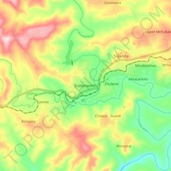
Name: Topografische Karte Butterworth, Höhe, Relief.
Durchschnittliche Höhe: 602 m
Minimale Höhe: 458 m
Maximale Höhe: 773 m
Andere topografische Karten
Klicken Sie auf eine Karte, um ihre Topografie, ihre Höhe und ihr Relief anzuzeigen.
Nqamakwe River
South Africa > Eastern Cape > Amathole District Municipality > Mnquma Local Municipality
Nqamakwe River, Mnquma Local Municipality, Amathole District Municipality, Eastern Cape, South Africa
Durchschnittliche Höhe: 763 m
Gcuwa River
South Africa > Eastern Cape > Amathole District Municipality > Mnquma Local Municipality > Butterworth
Gcuwa River, Mnquma Ward 1, Butterworth, Mnquma Local Municipality, Amathole District Municipality, Eastern Cape, 4960, South Africa
Durchschnittliche Höhe: 565 m