
Topografische Karte Bangkok
Interaktive Karte
Klicken Sie auf die Karte, um die Höhe anzuzeigen.
Über diese Karte
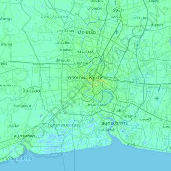
Name: Topografische Karte Bangkok, Höhe, Relief.
Ort: Bangkok, Phra Nakhon District, Bangkok, 10200, Thailand (13.49342 100.32788 13.95519 100.93844)
Durchschnittliche Höhe: 3 m
Minimale Höhe: -12 m
Maximale Höhe: 37 m
Bangkok is in the Chao Phraya River delta in Thailand's central plain. The river meanders through the city in a southerly direction, emptying into the Gulf of Thailand approximately 25 kilometres (16 mi) south of city centre. The area is flat and low-lying, with an average elevation of 1.5 metres (4 ft 11 in) above sea level. Most of the area was originally swampland, which was gradually drained and irrigated for agriculture by the construction of canals (khlong) which took place from the 16th to 19th centuries. The course of the river as it flows through Bangkok has been modified by the construction of several shortcut canals.
Andere topografische Karten
Klicken Sie auf eine Karte, um ihre Topografie, ihre Höhe und ihr Relief anzuzeigen.
Benchakitti Park
Benchakitti Park, Khlong Toei District, Bangkok, Thailand
Durchschnittliche Höhe: 9 m
Sanam Luang
Sanam Luang, Phra Nakhon District, Bangkok, 10200, Thailand
Durchschnittliche Höhe: 7 m
Bang Sue District
Bang Sue District, Bangkok, 10800, Thailand
Durchschnittliche Höhe: 5 m
Vadhana District
Vadhana District, Bangkok, 10110, Thailand
Durchschnittliche Höhe: 7 m
Khlong Toei District
Khlong Toei District, Bangkok, Thailand
Durchschnittliche Höhe: 7 m
Bang Khun Thian District
Bang Khun Thian District, Bangkok, 10150, Thailand
Durchschnittliche Höhe: 2 m
Lumphini Park
Lumphini Park, Pathum Wan District, Bangkok, 10330, Thailand
Durchschnittliche Höhe: 9 m
Bird Island
Bird Island, Bangkok, Dusit District, Bangkok, 10300, Thailand
Durchschnittliche Höhe: 7 m
Dao Khanong River
Dao Khanong River, Bangkok, Rat Burana District, Bangkok, 10140, Thailand
Durchschnittliche Höhe: 6 m