
Topografische Karte Great Salt Lake
Interaktive Karte
Klicken Sie auf die Karte, um die Höhe anzuzeigen.
Über diese Karte
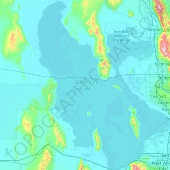
Name: Topografische Karte Great Salt Lake, Höhe, Relief.
Ort: Great Salt Lake, Utah, United States (40.66900 -113.00741 41.68375 -111.93021)
Durchschnittliche Höhe: 1.350 m
Minimale Höhe: 1.277 m
Maximale Höhe: 2.919 m
Drought conditions, climate change, and the overuse of snowmelt have caused the Great Salt Lake to shrink considerably. As of July 2022 the Great Salt Lake occupies some 950 square miles. In 1987, it occupied some 3300 square miles. As of March 2023, the lake's highest recorded surface elevation was 4,211.2 feet on April 15th, 1987; the lowest recorded surface elevation was 4,188.5 feet on December 17th, 2022. In 2023, it was estimated that without policy changes, the lake would dry up in 2028, with local species killed off by overly salty water somewhat before that.
Andere topografische Karten
Klicken Sie auf eine Karte, um ihre Topografie, ihre Höhe und ihr Relief anzuzeigen.
Ophir
United States > Utah > Tooele County
Ophir, Tooele County, Utah, United States
Durchschnittliche Höhe: 2.232 m
Garfield County
Garfield County, Utah, United States
Durchschnittliche Höhe: 1.907 m
Sandy
United States > Utah > Salt Lake County
Sandy, Salt Lake County, Utah, United States
Durchschnittliche Höhe: 1.376 m
drainage
United States > Utah > Salt Lake County > West Jordan
drainage, West Jordan, Salt Lake County, Utah, United States
Durchschnittliche Höhe: 1.389 m
Bayview Heights
United States > Utah > Davis County > Farmington
Bayview Heights, Farmington, Davis County, Utah, 84025, United States
Durchschnittliche Höhe: 1.457 m
Virgin
United States > Utah > Washington County
Virgin, Washington County, Utah, United States
Durchschnittliche Höhe: 1.251 m
Axtell
United States > Utah > Sanpete County
Axtell, Sanpete County, Utah, 84621, United States
Durchschnittliche Höhe: 1.572 m
Park City
United States > Utah > Summit County
Park City, Summit County, Utah, United States
Durchschnittliche Höhe: 2.290 m
Kimball Junction
United States > Utah > Summit County
Kimball Junction, Summit County, Utah, 84098, United States
Durchschnittliche Höhe: 2.004 m
Bear River
United States > Utah > Rich County
Bear River, Rich County, Utah, 84086, United States
Durchschnittliche Höhe: 1.924 m
Salt Lake City
United States > Utah > Salt Lake County > Salt Lake City
Salt Lake City, Salt Lake County, Utah, 84139, United States
Durchschnittliche Höhe: 1.625 m
Solitude
United States > Utah > Salt Lake County > Solitude
Solitude, Salt Lake County, Utah, United States
Durchschnittliche Höhe: 2.706 m
Paria Canyon
Paria Canyon, Kane County, Utah, United States
Durchschnittliche Höhe: 1.581 m
Aquarius Plateau
United States > Utah > Garfield County
Aquarius Plateau, Garfield County, Utah, United States
Durchschnittliche Höhe: 3.024 m
Colorado Plateau
United States > Utah > San Juan County
Colorado Plateau, San Juan County, Utah, United States
Durchschnittliche Höhe: 1.512 m
Jensen
United States > Utah > Uintah County > Jensen
Jensen, Uintah County, Utah, 84035, United States
Durchschnittliche Höhe: 1.470 m
Moab
United States > Utah > Grand County
Moab, Grand County, Utah, 84532, United States
Durchschnittliche Höhe: 1.357 m
Midvale
United States > Utah > Midvale
Midvale, Salt Lake County, Utah, 84047, United States
Durchschnittliche Höhe: 1.335 m
Farmington Heights
United States > Utah > Farmington > Farmington Heights
Farmington Heights, Farmington, Davis County, Utah, 84025, United States
Durchschnittliche Höhe: 1.511 m
Paria River
Paria River, Kane County, Utah, 84718, United States
Durchschnittliche Höhe: 1.802 m
West Jordan
United States > Utah > West Jordan
West Jordan, Salt Lake County, Utah, United States
Durchschnittliche Höhe: 1.372 m
Salt Lake City
United States > Utah > Salt Lake County
Salt Lake City, Salt Lake County, Utah, United States
Durchschnittliche Höhe: 1.592 m
Zion National Park
United States > Utah > Washington County
Zion National Park, Washington County, Utah, United States
Durchschnittliche Höhe: 1.877 m
Mount Nebo
United States > Utah > Juab County
Mount Nebo, Juab County, Utah, United States
Durchschnittliche Höhe: 3.115 m
South Jordan
United States > Utah > South Jordan
South Jordan, Salt Lake County, Utah, United States
Durchschnittliche Höhe: 1.383 m
Salt Lake County
Salt Lake County, Utah, United States
Durchschnittliche Höhe: 1.811 m
Provo
United States > Utah > Utah County
Provo, Utah County, Utah, United States
Durchschnittliche Höhe: 1.728 m
Duchesne County
Duchesne County, Utah, United States
Durchschnittliche Höhe: 2.408 m
Daggett County
Daggett County, Utah, United States
Durchschnittliche Höhe: 2.270 m
Saint George
United States > Utah > Washington County
Saint George, Washington County, Utah, United States
Durchschnittliche Höhe: 929 m