
Topografische Karte Calf Island
Interaktive Karte
Klicken Sie auf die Karte, um die Höhe anzuzeigen.
Über diese Karte
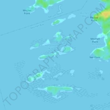
Name: Topografische Karte Calf Island, Höhe, Relief.
Durchschnittliche Höhe: 1 m
Minimale Höhe: -2 m
Maximale Höhe: 21 m
Andere topografische Karten
Klicken Sie auf eine Karte, um ihre Topografie, ihre Höhe und ihr Relief anzuzeigen.
Hartlings Island
Canada > Nova Scotia > Halifax County > Mitchell Bay
Hartlings Island, Mitchell Bay, Halifax Regional Municipality, Halifax County, Nova Scotia, Canada
Durchschnittliche Höhe: 1 m