
Topografische Karte Cotopaxi
Interaktive Karte
Klicken Sie auf die Karte, um die Höhe anzuzeigen.
Über diese Karte
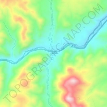
Name: Topografische Karte Cotopaxi, Höhe, Relief.
Ort: Cotopaxi, Fremont County, Colorado, United States (38.35028 -105.70806 38.39028 -105.66806)
Durchschnittliche Höhe: 2.093 m
Minimale Höhe: 1.921 m
Maximale Höhe: 2.392 m
Andere topografische Karten
Klicken Sie auf eine Karte, um ihre Topografie, ihre Höhe und ihr Relief anzuzeigen.
Penrose
United States > Colorado > Fremont County
Penrose, Fremont County, Colorado, United States
Durchschnittliche Höhe: 1.629 m
Coaldale
United States > Colorado > Fremont County
Coaldale, Fremont County, Colorado, United States
Durchschnittliche Höhe: 2.077 m
Howard
United States > Colorado > Fremont County > Howard
Howard, Fremont County, Colorado, 81233, United States
Durchschnittliche Höhe: 2.130 m
Coal Creek
United States > Colorado > Fremont County
Coal Creek, Fremont County, Colorado, 81221, United States
Durchschnittliche Höhe: 1.671 m