
Topografische Karte Linares
Interaktive Karte
Klicken Sie auf die Karte, um die Höhe anzuzeigen.
Linares
Most of the territory of the municipality is located within the central plain or "depresión intermedia" (Valle Central de Chile). Some low altitude hills are located in the westernmost part of the municipality, while its easternmost part is marked by the presence of the foothills of the Andes mountains. The municipality of Linares is bordered on the west by San Javier; on the north by Villa Alegre, Yerbas Buenas and Colbún; on the east, by Colbún, and on the south, by Longaví. The municipality of Colbún occupies the easternmost strip of the province, where some of the highest provincial peaks are located, as are the sources of several of the main rivers.
Über diese Karte
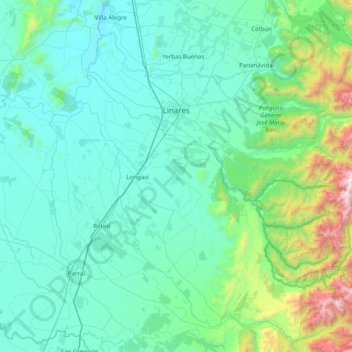
Name: Topografische Karte Linares, Höhe, Relief.
Ort: Linares, Provincia de Linares, Maule Region, Chile (-36.22591 -71.79710 -35.70333 -71.00628)
Durchschnittliche Höhe: 377 m
Minimale Höhe: 74 m
Maximale Höhe: 2.440 m
Andere topografische Karten
Klicken Sie auf eine Karte, um ihre Topografie, ihre Höhe und ihr Relief anzuzeigen.
Batuco
Chile > Maule Region > Provincia de Linares > Linares > Pamparraza
Durchschnittliche Höhe: 155 m
Los Cristales
Chile > Maule Region > Provincia de Linares > Longaví > Los Cristales
Durchschnittliche Höhe: 160 m