
Spenden
Rüste dich für dein nächstes Abenteuer:
Als Amazon-Partner verdient diese Website an qualifizierten Käufen, ohne zusätzliche Kosten für Sie.
Topografische Karte Green Lake
Klicken Sie auf die Karte, um die Höhe anzuzeigen.
Spenden
Rüste dich für dein nächstes Abenteuer:
Als Amazon-Partner verdient diese Website an qualifizierten Käufen, ohne zusätzliche Kosten für Sie.
Über diese Karte
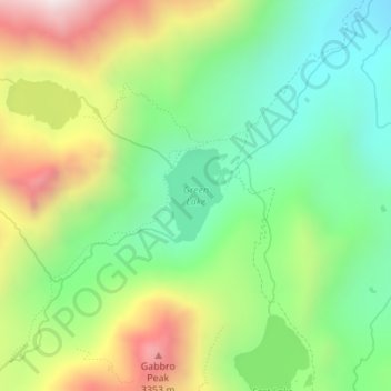
Name: Topografische Karte Green Lake, Höhe, Relief.
Ort: Green Lake, Mono County, California, United States (38.08163 -119.31194 38.08818 -119.30601)
Durchschnittliche Höhe: 2.902 m
Minimale Höhe: 2.558 m
Maximale Höhe: 3.458 m
Spenden
Rüste dich für dein nächstes Abenteuer:
Als Amazon-Partner verdient diese Website an qualifizierten Käufen, ohne zusätzliche Kosten für Sie.
Andere topografische Karten
Klicken Sie auf eine Karte, um ihre Topografie, ihre Höhe und ihr Relief anzuzeigen.
June Lake
United States > California > Mono County
June Lake is an unincorporated community and census-designated place (CDP) in Mono County, California, United States. It is located against the southern rim of the Mono Basin, 12.5 miles (20 km) south of Lee Vining, at an elevation of 7,654 feet (2,333 m).
Durchschnittliche Höhe: 2.548 m
Lee Vining
United States > California > Mono County
Lee Vining (formerly Leevining, Poverty Flat, and Lakeview) is an unincorporated community and census-designated place (CDP) in Mono County, California, United States. It is located 25 miles (40 km) south-southeast of Bridgeport, at an elevation of 6,781 feet (2,067 m). Lee Vining is located on the southwest…
Durchschnittliche Höhe: 2.180 m
Spenden
Rüste dich für dein nächstes Abenteuer:
Als Amazon-Partner verdient diese Website an qualifizierten Käufen, ohne zusätzliche Kosten für Sie.
Spenden
Rüste dich für dein nächstes Abenteuer:
Als Amazon-Partner verdient diese Website an qualifizierten Käufen, ohne zusätzliche Kosten für Sie.
Mono Lake Tufa State Natural Reserve
United States > California > Mono County
Durchschnittliche Höhe: 2.090 m
Virginia Lakes
United States > California > Mono County > Virginia Lakes
Durchschnittliche Höhe: 3.114 m
Spenden
Rüste dich für dein nächstes Abenteuer:
Als Amazon-Partner verdient diese Website an qualifizierten Käufen, ohne zusätzliche Kosten für Sie.
Spenden
Rüste dich für dein nächstes Abenteuer:
Als Amazon-Partner verdient diese Website an qualifizierten Käufen, ohne zusätzliche Kosten für Sie.