
Topografische Karte New Zaniga
Interaktive Karte
Klicken Sie auf die Karte, um die Höhe anzuzeigen.
Über diese Karte
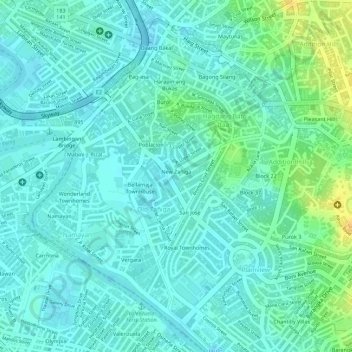
Name: Topografische Karte New Zaniga, Höhe, Relief.
Ort: New Zaniga, Mandaluyong, Metro Manila, Philippines (14.58067 121.02720 14.58704 121.03189)
Durchschnittliche Höhe: 11 m
Minimale Höhe: 2 m
Maximale Höhe: 31 m
Andere topografische Karten
Klicken Sie auf eine Karte, um ihre Topografie, ihre Höhe und ihr Relief anzuzeigen.
Malamig
Malamig, Mandaluyong, Eastern Manila District, Metro Manila, Philippines
Durchschnittliche Höhe: 24 m
Pasig River
Pasig River, Namayan, District I, Mandaluyong, Eastern Manila District, Metro Manila, 1009, Philippines
Durchschnittliche Höhe: 8 m
Daang Bakal
Daang Bakal, Mandaluyong, Eastern Manila District, Metro Manila, Philippines
Durchschnittliche Höhe: 12 m
Mandala Park
Mandala Park, Liberty Center, Mandaluyong, Eastern Manila District, Metro Manila, 1552, Philippines
Durchschnittliche Höhe: 23 m
Wack-Wack Greenhills
Wack-Wack Greenhills, Mandaluyong, Eastern Manila District, Metro Manila, Philippines
Durchschnittliche Höhe: 37 m
Hulo
Hulo, Mandaluyong, Eastern Manila District, Metro Manila, Philippines
Durchschnittliche Höhe: 13 m
Highway Hills
Highway Hills, Mandaluyong, Metro Manila, Philippines
Durchschnittliche Höhe: 32 m
Addition Hills
Addition Hills, Mandaluyong, Metro Manila, 1550, Philippines
Durchschnittliche Höhe: 18 m
Barangka Ibaba
Barangka Ibaba, Mandaluyong, Metro Manila, Philippines
Durchschnittliche Höhe: 18 m
Mauway
Mauway, Mandaluyong, Metro Manila, Philippines
Durchschnittliche Höhe: 22 m
Old Zañiga
Old Zañiga, Mandaluyong, Eastern Manila District, Metro Manila, Philippines
Durchschnittliche Höhe: 9 m
Plainview
Plainview, Mandaluyong, Metro Manila, 1551, Philippines
Durchschnittliche Höhe: 16 m