
Topografische Karte Oklahoma City
Interaktive Karte
Klicken Sie auf die Karte, um die Höhe anzuzeigen.
Über diese Karte
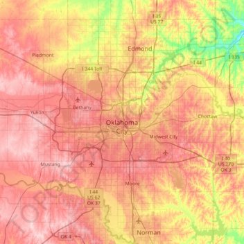
Name: Topografische Karte Oklahoma City, Höhe, Relief.
Ort: Oklahoma City, Oklahoma County, Oklahoma, United States (35.29070 -97.83095 35.67487 -97.12472)
Durchschnittliche Höhe: 362 m
Minimale Höhe: 269 m
Maximale Höhe: 434 m
Andere topografische Karten
Klicken Sie auf eine Karte, um ihre Topografie, ihre Höhe und ihr Relief anzuzeigen.
Jones
United States > Oklahoma > Oklahoma County
Jones, Oklahoma County, Oklahoma, United States
Durchschnittliche Höhe: 354 m
Del City
United States > Oklahoma > Oklahoma County
Del City, Oklahoma County, Oklahoma, 73115, United States
Durchschnittliche Höhe: 369 m
Luther
United States > Oklahoma > Oklahoma County
Luther, Oklahoma County, Oklahoma, United States
Durchschnittliche Höhe: 296 m
Lightning Creek Holding Pond B Dam
United States > Oklahoma > Oklahoma County > Oklahoma City
Lightning Creek Holding Pond B Dam, Oklahoma City, Oklahoma County, Oklahoma, 73159, United States
Durchschnittliche Höhe: 386 m
Oklahoma City
United States > Oklahoma > Oklahoma County > Oklahoma City
Oklahoma City, Oklahoma County, Oklahoma, 73104:73106, United States
Durchschnittliche Höhe: 370 m
Edmond
United States > Oklahoma > Oklahoma County > Edmond
Edmond, Oklahoma County, Oklahoma, 73083, United States
Durchschnittliche Höhe: 343 m