
Spenden
Rüste dich für dein nächstes Abenteuer:
Als Amazon-Partner verdient diese Website an qualifizierten Käufen, ohne zusätzliche Kosten für Sie.
Topografische Karte Parleys Canyon
Klicken Sie auf die Karte, um die Höhe anzuzeigen.
Spenden
Rüste dich für dein nächstes Abenteuer:
Als Amazon-Partner verdient diese Website an qualifizierten Käufen, ohne zusätzliche Kosten für Sie.
Parleys Canyon
Parleys Canyon is a canyon located in the U.S. state of Utah. The canyon provides the route of Interstate 80 (I-80) (and previously the Lincoln Highway, U.S. Route 40, and a railroad) up the western slope of the Wasatch Mountains and is a relatively wide, straight canyon other than near its mouth. The mountain pass at the top of the canyon is known as Parleys Summit. With an elevation of 7,120 feet (2,170 m), the pass is the highest point along I-80 in the state of Utah. Both features are named for Parley P. Pratt, an early settler of the Salt Lake Valley and leader of the Church of Jesus Christ of Latter-day Saints who surveyed the area to find a better transportation route through the Wasatch Mountains than the previous route which traversed Emigration Canyon.
Spenden
Rüste dich für dein nächstes Abenteuer:
Als Amazon-Partner verdient diese Website an qualifizierten Käufen, ohne zusätzliche Kosten für Sie.
Über diese Karte
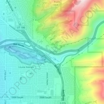
Name: Topografische Karte Parleys Canyon, Höhe, Relief.
Durchschnittliche Höhe: 1.577 m
Minimale Höhe: 1.405 m
Maximale Höhe: 1.984 m
Spenden
Rüste dich für dein nächstes Abenteuer:
Als Amazon-Partner verdient diese Website an qualifizierten Käufen, ohne zusätzliche Kosten für Sie.