
Topografische Karte City of Manningham
Interaktive Karte
Klicken Sie auf die Karte, um die Höhe anzuzeigen.
Über diese Karte
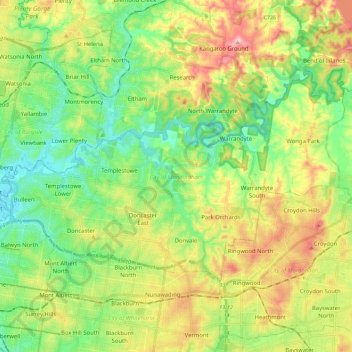
Name: Topografische Karte City of Manningham, Höhe, Relief.
Ort: City of Manningham, Victoria, Austrália (-37.81177 145.06711 -37.70244 145.29393)
Durchschnittliche Höhe: 96 m
Minimale Höhe: 11 m
Maximale Höhe: 239 m
Andere topografische Karten
Klicken Sie auf eine Karte, um ihre Topografie, ihre Höhe und ihr Relief anzuzeigen.
Rural City of Benalla
Rural City of Benalla, Victoria, Austrália
Durchschnittliche Höhe: 294 m
Rural City of Wangaratta
Rural City of Wangaratta, Victoria, Austrália
Durchschnittliche Höhe: 435 m
Wangaratta
Wangaratta, Rural City of Wangaratta, Victoria, Austrália
Durchschnittliche Höhe: 148 m
Rural City of Mildura
Rural City of Mildura, Victoria, Austrália
Durchschnittliche Höhe: 65 m
Port Campbell National Park
Austrália > Victoria > Port Campbell
Port Campbell National Park, Port Campbell, Shire of Corangamite, Victoria, 3269, Austrália
Durchschnittliche Höhe: 18 m
City of Melbourne
City of Melbourne, Victoria, Austrália
Durchschnittliche Höhe: 20 m
Dinner Plain
Austrália > Victoria > Dinner Plain
Dinner Plain, Alpine Shire, Victoria, Austrália
Durchschnittliche Höhe: 1.473 m
Wingan River
Wingan River, Shire of East Gippsland, Victoria, Austrália
Durchschnittliche Höhe: 131 m
Mount Sunday
Mount Sunday, Shire of Mansfield, Victoria, Austrália
Durchschnittliche Höhe: 1.141 m
City of Moreland
City of Moreland, Victoria, Austrália
Durchschnittliche Höhe: 64 m
Western Port
Western Port, Causeway Road Extension, French Island, Gippsland, Victoria, 3921, Austrália
Durchschnittliche Höhe: 0 m
Croajingolong NP
Croajingolong NP, Lake Barracotta Link Track, Genoa, Shire of East Gippsland, Gippsland, Victoria, Austrália
Durchschnittliche Höhe: 50 m
Birrarung Marr
Birrarung Marr, St Kilda Road, Melbourne City, City of Melbourne, Victoria, 3000, Austrália
Durchschnittliche Höhe: 23 m
City of Stonnington
City of Stonnington, Victoria, Austrália
Durchschnittliche Höhe: 40 m