
Topografische Karte Tabriz
Interaktive Karte
Klicken Sie auf die Karte, um die Höhe anzuzeigen.
Über diese Karte
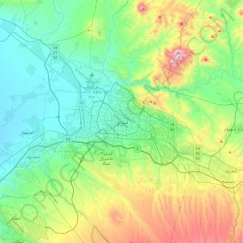
Name: Topografische Karte Tabriz, Höhe, Relief.
Durchschnittliche Höhe: 1.594 m
Minimale Höhe: 1.312 m
Maximale Höhe: 2.364 m
Tabriz (Persian: تبریز (listen); Azerbaijani: تبریز) is the most populated city in northwestern Iran, one of the historical capitals of Iran and the present capital of East Azerbaijan province. It is the sixth most populous city in Iran. Located in the Quru River valley, in Iran's historic Azerbaijan region, between long ridges of volcanic cones in the Sahand and Eynali mountains, Tabriz's elevation ranges between 1,350 and 1,600 metres (4,430 and 5,250 ft) above sea level. The valley opens up into a plain that gently slopes down to the eastern shores of Lake Urmia, 60 kilometres (37 miles) to the west. With cold winters and temperate summers, Tabriz is considered a summer resort. It was named World Carpet Weaving City by the World Crafts Council in October 2015 and Exemplary Tourist City of 2018 by the Organisation of Islamic Cooperation.