
Topografische Karte Marsh Hart Knob
Interaktive Karte
Klicken Sie auf die Karte, um die Höhe anzuzeigen.
Über diese Karte
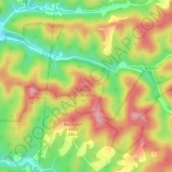
Name: Topografische Karte Marsh Hart Knob, Höhe, Relief.
Durchschnittliche Höhe: 284 m
Minimale Höhe: 217 m
Maximale Höhe: 344 m
Andere topografische Karten
Klicken Sie auf eine Karte, um ihre Topografie, ihre Höhe und ihr Relief anzuzeigen.
Vicars
United States > West Virginia > Roane County
Vicars, Roane County, West Virginia, United States
Durchschnittliche Höhe: 271 m
Moore
United States > West Virginia > Roane County
Moore, Roane County, West Virginia, 25270, United States
Durchschnittliche Höhe: 266 m
Rose Hill
United States > West Virginia > Roane County
Rose Hill, Roane County, West Virginia, United States
Durchschnittliche Höhe: 295 m
Walton
United States > West Virginia > Roane County
Walton, Roane County, West Virginia, 25286, United States
Durchschnittliche Höhe: 266 m
Spencer
United States > West Virginia > Roane County
Spencer, Roane County, West Virginia, 25276, United States
Durchschnittliche Höhe: 264 m
Schilling Addition
United States > West Virginia > Roane County > Spencer
Schilling Addition, Spencer, Roane County, West Virginia, 25276, United States
Durchschnittliche Höhe: 265 m
Cotton
United States > West Virginia > Roane County
Cotton, Roane County, West Virginia, United States
Durchschnittliche Höhe: 276 m
Spencer
United States > West Virginia > Roane County > Spencer > Spencer
Spencer, Roane County, West Virginia, 25276, United States
Durchschnittliche Höhe: 280 m
Gandeeville
United States > West Virginia > Roane County > Gandeeville
Gandeeville, Roane County, West Virginia, United States
Durchschnittliche Höhe: 284 m
Harmony
United States > West Virginia > Roane County > Harmony
Harmony, Roane County, West Virginia, 25243, United States
Durchschnittliche Höhe: 276 m
Depue
United States > West Virginia > Roane County > Depue
Depue, Roane County, West Virginia, United States
Durchschnittliche Höhe: 273 m
Reedy
United States > West Virginia > Roane County
Reedy, Roane County, West Virginia, United States
Durchschnittliche Höhe: 249 m