
Topografische Karte West Sacramento
Interaktive Karte
Klicken Sie auf die Karte, um die Höhe anzuzeigen.
Über diese Karte
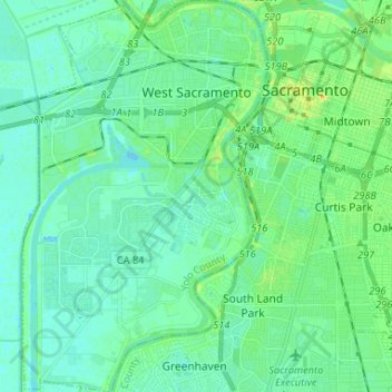
Name: Topografische Karte West Sacramento, Höhe, Relief.
Ort: West Sacramento, Yolo County, California, United States (38.50194 -121.58835 38.60446 -121.50630)
Durchschnittliche Höhe: 7 m
Minimale Höhe: -1 m
Maximale Höhe: 27 m
Andere topografische Karten
Klicken Sie auf eine Karte, um ihre Topografie, ihre Höhe und ihr Relief anzuzeigen.
Dufour
United States > California > Yolo County
Dufour, Yolo County, California, 95697, United States
Durchschnittliche Höhe: 18 m
Woodland
United States > California > Yolo County
Woodland, Yolo County, California, 95695, United States
Durchschnittliche Höhe: 18 m
Central
United States > California > Yolo County
Central, Yolo County, California, United States
Durchschnittliche Höhe: 1 m