
Topografische Karte Krishnanagar
Interaktive Karte
Klicken Sie auf die Karte, um die Höhe anzuzeigen.
Krishnanagar
Krishnanagar is located at 23°24′N 88°30′E / 23.4°N 88.5°E / 23.4; 88.5. The area of the municipality is around 16 km2. It is situated on the southern banks of the Jalangi River. It has an average elevation of 14 metres (46 ft). The Tropic of Cancer passes through the outskirts of Krishnanagar. The latitude of the Tropic of Cancer is 23° 26′ 5″ N.
Über diese Karte
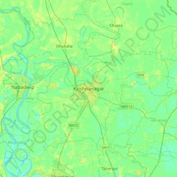
Name: Topografische Karte Krishnanagar, Höhe, Relief.
Durchschnittliche Höhe: 11 m
Minimale Höhe: 3 m
Maximale Höhe: 29 m