
Topografische Karte Guadix
Interaktive Karte
Klicken Sie auf die Karte, um die Höhe anzuzeigen.
Über diese Karte
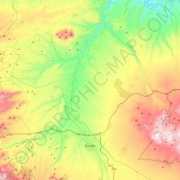
Name: Topografische Karte Guadix, Höhe, Relief.
Ort: Guadix, Comarca de Guadix, Granada, Andalusia, Spain (37.23862 -3.26153 37.56132 -2.93718)
Durchschnittliche Höhe: 1.043 m
Minimale Höhe: 555 m
Maximale Höhe: 1.763 m
The city lies at an altitude of 913 metres,[2] on the centre of the Hoya of Guadix, a high plain at the northern foothills of the Sierra Nevada. It is located on the Madrid-Valdepeñas-Almería railway.
Andere topografische Karten
Klicken Sie auf eine Karte, um ihre Topografie, ihre Höhe und ihr Relief anzuzeigen.
La Calahorra
Spain > Andalusia > Comarca de Guadix
La Calahorra, Comarca de Guadix, Granada, Andalusia, Spain
Durchschnittliche Höhe: 1.148 m
Purullena
Spain > Andalusia > Comarca de Guadix > Purullena
Purullena, Comarca de Guadix, Granada, Andalusia, 18519, Spain
Durchschnittliche Höhe: 900 m