
Topografische Karte Porcupine District
Interaktive Karte
Klicken Sie auf die Karte, um die Höhe anzuzeigen.
Über diese Karte
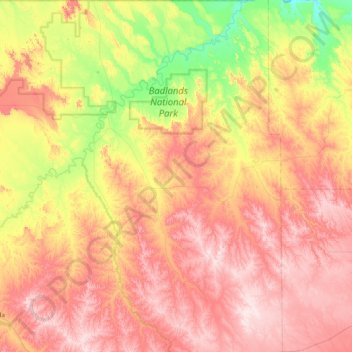
Name: Topografische Karte Porcupine District, Höhe, Relief.
Durchschnittliche Höhe: 925 m
Minimale Höhe: 720 m
Maximale Höhe: 1.122 m
Andere topografische Karten
Klicken Sie auf eine Karte, um ihre Topografie, ihre Höhe und ihr Relief anzuzeigen.
Badlands National Park
United States > South Dakota > Oglala Lakota County
Badlands National Park, Oglala Lakota County, South Dakota, 57750, United States
Durchschnittliche Höhe: 848 m
Red Shirt
United States > South Dakota > Oglala Lakota County
Red Shirt, White Clay District, Oglala Lakota County, South Dakota, United States
Durchschnittliche Höhe: 845 m