
Topografische Karte Ivanhoe
Interaktive Karte
Klicken Sie auf die Karte, um die Höhe anzuzeigen.
Über diese Karte
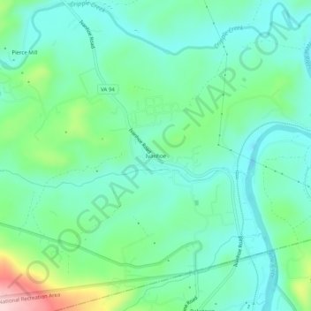
Name: Topografische Karte Ivanhoe, Höhe, Relief.
Ort: Ivanhoe, Wythe County, Virginia, 24350, United States (36.82012 -80.98675 36.86012 -80.94675)
Durchschnittliche Höhe: 643 m
Minimale Höhe: 578 m
Maximale Höhe: 837 m
Andere topografische Karten
Klicken Sie auf eine Karte, um ihre Topografie, ihre Höhe und ihr Relief anzuzeigen.
Austinville
United States > Virginia > Wythe County
Austinville, Wythe County, Virginia, 24312, United States
Durchschnittliche Höhe: 645 m
Cripple Creek
United States > Virginia > Wythe County > Speedwell
Cripple Creek, Speedwell, Wythe County, Virginia, 24374, United States
Durchschnittliche Höhe: 733 m
Wytheville
United States > Virginia > Wythe County
Wytheville, Wythe County, Virginia, 24382, United States
Durchschnittliche Höhe: 720 m
Barren Springs
United States > Virginia > Wythe County
Barren Springs, Wythe County, Virginia, 24313, United States
Durchschnittliche Höhe: 642 m
Max Meadows
United States > Virginia > Wythe County
Max Meadows, Wythe County, Virginia, United States
Durchschnittliche Höhe: 662 m
Stones Mill
United States > Virginia > Wythe County > Wytheville > Stones Mill
Stones Mill, Wytheville, Wythe County, Virginia, 24382, United States
Durchschnittliche Höhe: 710 m