
Topografische Karte Spirit Lake
Interaktive Karte
Klicken Sie auf die Karte, um die Höhe anzuzeigen.
Über diese Karte
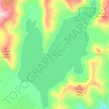
Name: Topografische Karte Spirit Lake, Höhe, Relief.
Ort: Spirit Lake, Skamania County, Washington, United States (46.24663 -122.16614 46.29837 -122.11151)
Durchschnittliche Höhe: 1.144 m
Minimale Höhe: 905 m
Maximale Höhe: 1.609 m
Prior to 1980, Spirit Lake consisted of two arms that occupied what had been the valleys of the North Fork Toutle River and a tributary. About 4,000 years ago, these valleys were blocked by lahars and pyroclastic flow deposits from Mount St. Helens to form the pre-1980 Spirit Lake. The longest branch of Spirit Lake was about 2.1 miles (3.4 km) long. A stable outlet channel flowed from the lake to the North Fork Toutle River across a natural dam composed of volcanic material. The level of Spirit Lake remained basically stable, at an altitude of about 3,198 ft (970 m).
Andere topografische Karten
Klicken Sie auf eine Karte, um ihre Topografie, ihre Höhe und ihr Relief anzuzeigen.
Gifford Pinchot National Forest
United States > Washington > Skamania County
Gifford Pinchot National Forest, Skamania County, Washington, United States
Durchschnittliche Höhe: 769 m
Mount Saint Helens
United States > Washington > Skamania County
Mount Saint Helens, Skamania County, Washington, United States
Durchschnittliche Höhe: 2.096 m