
Topografische Karte North Wales
Interaktive Karte
Klicken Sie auf die Karte, um die Höhe anzuzeigen.
Über diese Karte
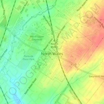
Name: Topografische Karte North Wales, Höhe, Relief.
Ort: North Wales, Montgomery County, Pennsylvania, United States (40.20362 -75.28450 40.21917 -75.26415)
Durchschnittliche Höhe: 113 m
Minimale Höhe: 85 m
Maximale Höhe: 141 m
Andere topografische Karten
Klicken Sie auf eine Karte, um ihre Topografie, ihre Höhe und ihr Relief anzuzeigen.
Horsham
United States > Pennsylvania > Montgomery County > Horsham Township
Horsham, Horsham Township, Montgomery County, Pennsylvania, 19044, United States
Durchschnittliche Höhe: 89 m
Willow Grove
United States > Pennsylvania > Montgomery County > Upper Moreland Township
Willow Grove, Upper Moreland Township, Montgomery County, Pennsylvania, 19090, United States
Durchschnittliche Höhe: 91 m
Rydal
United States > Pennsylvania > Montgomery County > Abington Township
Rydal, Abington Township, Montgomery County, Pennsylvania, 19046, United States
Durchschnittliche Höhe: 84 m
Willow Grove
United States > Pennsylvania > Montgomery County > Upper Moreland Township > Willow Grove
Willow Grove, Upper Moreland Township, Montgomery County, Pennsylvania, 19090, United States
Durchschnittliche Höhe: 88 m
Bob Case Park
United States > Pennsylvania > Montgomery County > Upper Merion Township > King of Prussia > Sweet Briar
Bob Case Park, Sweet Briar, King of Prussia, Upper Merion Township, Montgomery County, Pennsylvania, 19406, United States
Durchschnittliche Höhe: 45 m
Audubon
United States > Pennsylvania > Montgomery County > Lower Providence Township > Audubon
Audubon, Lower Providence Township, Montgomery County, Pennsylvania, 19456, United States
Durchschnittliche Höhe: 55 m
King of Prussia
United States > Pennsylvania > Montgomery County > King of Prussia
King of Prussia, Montgomery County, Pennsylvania, United States
Durchschnittliche Höhe: 59 m