
Topografische Karte Artic
Interaktive Karte
Klicken Sie auf die Karte, um die Höhe anzuzeigen.
Über diese Karte
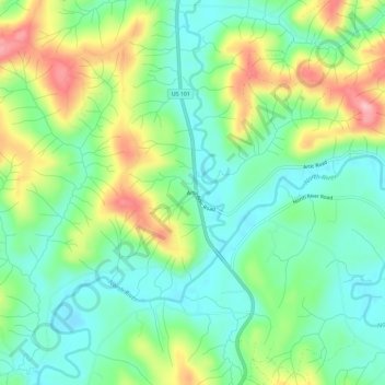
Name: Topografische Karte Artic, Höhe, Relief.
Ort: Artic, Grays Harbor County, Washington, United States (46.87032 -123.73528 46.91032 -123.69528)
Durchschnittliche Höhe: 75 m
Minimale Höhe: 22 m
Maximale Höhe: 175 m
Andere topografische Karten
Klicken Sie auf eine Karte, um ihre Topografie, ihre Höhe und ihr Relief anzuzeigen.
Vesta
United States > Washington > Grays Harbor County
Vesta, Grays Harbor County, Washington, United States
Durchschnittliche Höhe: 86 m
Roosevelt Beach Conservation Area
United States > Washington > Grays Harbor County > Ocean Grove
Roosevelt Beach Conservation Area, Ocean Grove, Grays Harbor County, Washington, United States
Durchschnittliche Höhe: 18 m
Humptulips
United States > Washington > Grays Harbor County
Humptulips, Grays Harbor County, Washington, United States
Durchschnittliche Höhe: 108 m
Grisdale
United States > Washington > Grays Harbor County
Grisdale, Grays Harbor County, Washington, United States
Durchschnittliche Höhe: 354 m
Elma
United States > Washington > Grays Harbor County > Elma
Elma, Grays Harbor County, Washington, United States
Durchschnittliche Höhe: 36 m
Ocean Shores
United States > Washington > Grays Harbor County
Ocean Shores, Grays Harbor County, Washington, 98569, United States
Durchschnittliche Höhe: 1 m
McCleary
United States > Washington > Grays Harbor County > McCleary > McCleary
McCleary, Grays Harbor County, Washington, 98557, United States
Durchschnittliche Höhe: 108 m