Geolokalisieren

Topografische Karte Kiel

Interaktive Karte

Klicken Sie auf die Karte, um die Höhe anzuzeigen.

Über diese Karte

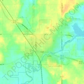
Name: Topografische Karte Kiel, Höhe, Relief.

Ort: Kiel, Manitowoc County, Wisconsin, United States (43.90535 -88.05398 43.92921 -87.99760)

Durchschnittliche Höhe: 279 m

Minimale Höhe: 265 m

Maximale Höhe: 294 m

Andere topografische Karten

Klicken Sie auf eine Karte, um ihre Topografie, ihre Höhe und ihr Relief anzuzeigen.

Woods

United States > Wisconsin > Manitowoc County > Manitowoc

Woods, Manitowoc, Manitowoc County, Wisconsin, United States

Durchschnittliche Höhe: 209 m

Cato

United States > Wisconsin > Manitowoc County

Cato, Town of Cato, Manitowoc County, Wisconsin, 52427, United States

Durchschnittliche Höhe: 261 m

Manitowoc

United States > Wisconsin > Manitowoc County

Manitowoc, Manitowoc County, Wisconsin, United States

Durchschnittliche Höhe: 191 m

Valders

United States > Wisconsin > Manitowoc County > Valders

Valders, Manitowoc County, Wisconsin, United States

Durchschnittliche Höhe: 261 m

Two Rivers

United States > Wisconsin > Manitowoc County

Two Rivers, Manitowoc County, Wisconsin, 54241, United States

Durchschnittliche Höhe: 180 m

Cleveland

United States > Wisconsin > Manitowoc County

Cleveland, Manitowoc County, Wisconsin, United States

Durchschnittliche Höhe: 200 m

Larrabee

United States > Wisconsin > Manitowoc County

Larrabee, Town of Gibson, Manitowoc County, Wisconsin, United States

Durchschnittliche Höhe: 215 m