
Topografische Karte Crandall
Interaktive Karte
Klicken Sie auf die Karte, um die Höhe anzuzeigen.
Über diese Karte
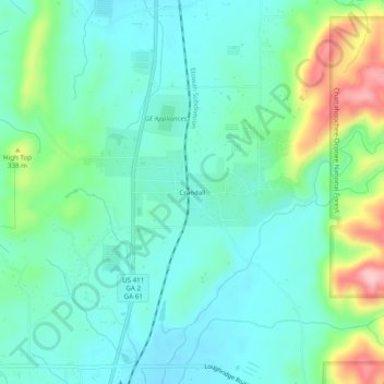
Name: Topografische Karte Crandall, Höhe, Relief.
Ort: Crandall, Murray County, Georgia, 30724, United States (34.84675 -84.76549 34.88675 -84.72549)
Durchschnittliche Höhe: 276 m
Minimale Höhe: 229 m
Maximale Höhe: 417 m
Andere topografische Karten
Klicken Sie auf eine Karte, um ihre Topografie, ihre Höhe und ihr Relief anzuzeigen.
Iron Mountain
United States > Georgia > Murray County
Iron Mountain, Murray County, Georgia, United States
Durchschnittliche Höhe: 362 m
Cisco
United States > Georgia > Murray County
Cisco, Murray County, Georgia, 30708, United States
Durchschnittliche Höhe: 293 m
Fort Mountain State Park
United States > Georgia > Murray County
Fort Mountain State Park, Murray County, Georgia, United States
Durchschnittliche Höhe: 596 m
Eton
United States > Georgia > Murray County
Eton, Murray County, Georgia, 30724, United States
Durchschnittliche Höhe: 236 m
Chatsworth
United States > Georgia > Murray County
Chatsworth, Murray County, Georgia, United States
Durchschnittliche Höhe: 241 m