
Topografische Karte Trillou
Interaktive Karte
Klicken Sie auf die Karte, um die Höhe anzuzeigen.
Über diese Karte
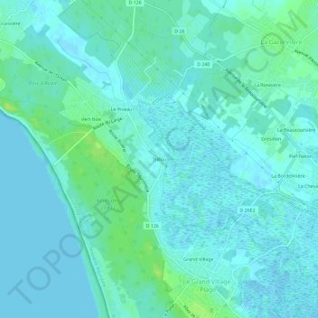
Name: Topografische Karte Trillou, Höhe, Relief.
Durchschnittliche Höhe: 4 m
Minimale Höhe: -1 m
Maximale Höhe: 13 m
Andere topografische Karten
Klicken Sie auf eine Karte, um ihre Topografie, ihre Höhe und ihr Relief anzuzeigen.
La Giraudière
France > Nouvelle-Aquitaine > Charente-Maritime > Le Grand-Village-Plage
La Giraudière, Le Grand-Village-Plage, Rochefort, Charente-Maritime, Nouvelle-Aquitaine, France métropolitaine, 17370, France
Durchschnittliche Höhe: 4 m
Grand-Village
France > Nouvelle-Aquitaine > Charente-Maritime > Le Grand-Village-Plage
Grand-Village, Le Grand-Village-Plage, Rochefort, Charente-Maritime, Nouvelle-Aquitaine, France métropolitaine, 17370, France
Durchschnittliche Höhe: 4 m
Petit-Village
France > Nouvelle-Aquitaine > Charente-Maritime > Le Grand-Village-Plage
Petit-Village, Le Grand-Village-Plage, Rochefort, Charente-Maritime, Nouvelle-Aquitaine, France métropolitaine, 17370, France
Durchschnittliche Höhe: 4 m