
Topografische Karte Panaji
Interaktive Karte
Klicken Sie auf die Karte, um die Höhe anzuzeigen.
Über diese Karte
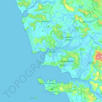
Name: Topografische Karte Panaji, Höhe, Relief.
Ort: Panaji, Tiswadi, North Goa, Goa, 403001, India (15.33899 73.66821 15.65899 73.98821)
Durchschnittliche Höhe: 19 m
Minimale Höhe: -3 m
Maximale Höhe: 285 m
Panaji was annexed by India with the rest of Goa and the former Portuguese territories after the Indian annexation of Portuguese India in 1961. It became a state-capital on Goa's elevation to statehood in 1987. Between 1961 and 1987, it was the capital of the Union Territory of Goa, Daman and Diu. A new Legislative Assembly complex was inaugurated in March 2000, across the Mandovi River, in Alto Porvorim. Panaji is also the administrative headquarters of North Goa district.
Andere topografische Karten
Klicken Sie auf eine Karte, um ihre Topografie, ihre Höhe und ihr Relief anzuzeigen.
Carambolim
Carambolim, Tiswadi, North Goa, Goa, 403110, India
Durchschnittliche Höhe: 17 m