
Spenden
Rüste dich für dein nächstes Abenteuer:
Als Amazon-Partner verdient diese Website an qualifizierten Käufen, ohne zusätzliche Kosten für Sie.
Topografische Karte San Andreas
Klicken Sie auf die Karte, um die Höhe anzuzeigen.
Spenden
Rüste dich für dein nächstes Abenteuer:
Als Amazon-Partner verdient diese Website an qualifizierten Käufen, ohne zusätzliche Kosten für Sie.
Über diese Karte
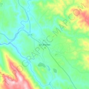
Name: Topografische Karte San Andreas, Höhe, Relief.
Durchschnittliche Höhe: 377 m
Minimale Höhe: 211 m
Maximale Höhe: 785 m
Spenden
Rüste dich für dein nächstes Abenteuer:
Als Amazon-Partner verdient diese Website an qualifizierten Käufen, ohne zusätzliche Kosten für Sie.
Andere topografische Karten
Klicken Sie auf eine Karte, um ihre Topografie, ihre Höhe und ihr Relief anzuzeigen.
Murphys
United States > California > Calaveras County > Murphys
"MURPHY'S CAMP is a curious old mining-town in Calaveras County, at an elevation of 2,400 feet (730 m) above the sea, situated like a nest in the center of a rough, gravelly region, rich in gold. Granites, slates, lavas, limestone, iron ores, quartz veins, auriferous gravels, remnants of dead fire-rivers and…
Durchschnittliche Höhe: 735 m
Dorrington
United States > California > Calaveras County
According to the United States Census Bureau, the CDP has a total area of 3.7 square miles (9.6 km2), 99.86% of it land. The elevation is 4,800 feet ASL.
Durchschnittliche Höhe: 1.464 m
Spenden
Rüste dich für dein nächstes Abenteuer:
Als Amazon-Partner verdient diese Website an qualifizierten Käufen, ohne zusätzliche Kosten für Sie.
Angels
United States > California > Calaveras County
Angels Camp, also known as City of Angels and formerly Angel's Camp, Angels, Angels City, Carson's Creek and Clearlake, is the only incorporated city in Calaveras County, California, United States. The population was 3,836 at the 2010 census, up from 3,004 at the 2000 census. It lies at an elevation of 1378…
Durchschnittliche Höhe: 459 m
Spenden
Rüste dich für dein nächstes Abenteuer:
Als Amazon-Partner verdient diese Website an qualifizierten Käufen, ohne zusätzliche Kosten für Sie.
Angels Camp
United States > California > Calaveras County
Angels Camp, also known as City of Angels and formerly Angel's Camp, Angels, Angels City, Carson's Creek and Clearlake, is the only incorporated city in Calaveras County, California, United States. The population was 3,836 at the 2010 census, up from 3,004 at the 2000 census. It lies at an elevation of 1378…
Durchschnittliche Höhe: 461 m
Spenden
Rüste dich für dein nächstes Abenteuer:
Als Amazon-Partner verdient diese Website an qualifizierten Käufen, ohne zusätzliche Kosten für Sie.
Dorrington
United States > California > Calaveras County
According to the United States Census Bureau, the CDP has a total area of 3.7 square miles (9.6 km2), 99.86% of it land. The elevation is 4,800 feet ASL.
Durchschnittliche Höhe: 1.464 m
Calaveras Big Trees State Park
United States > California > Calaveras County
Durchschnittliche Höhe: 1.375 m
Spenden
Rüste dich für dein nächstes Abenteuer:
Als Amazon-Partner verdient diese Website an qualifizierten Käufen, ohne zusätzliche Kosten für Sie.