
Topografische Karte Morasko
Interaktive Karte
Klicken Sie auf die Karte, um die Höhe anzuzeigen.
Über diese Karte
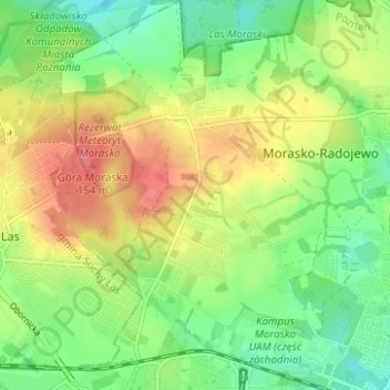
Name: Topografische Karte Morasko, Höhe, Relief.
Durchschnittliche Höhe: 108 m
Minimale Höhe: 78 m
Maximale Höhe: 146 m
West of Morasko village is the Morasko meteorite nature reserve, a forest area containing a group of depressions believed to be meteorite craters. Also within this reserve is Góra Moraska (Morasko Hill), whose summit is Poznań's highest point, with an altitude of 157 metres (515 ft). An avenue of trees along the road leading from the village to the reserve is designated as a natural monument.
Andere topografische Karten
Klicken Sie auf eine Karte, um ihre Topografie, ihre Höhe und ihr Relief anzuzeigen.
Szczepankowo-Spławie-Krzesinki
Poland > Greater Poland Voivodeship > Poznań
Szczepankowo-Spławie-Krzesinki, Poznan, Greater Poland Voivodeship, Poland
Durchschnittliche Höhe: 82 m
Starołęka Mała
Poland > Greater Poland Voivodeship > Poznań
Starołęka Mała, Starołęka-Minikowo-Marlewo, Poznań, Greater Poland Voivodeship, Poland
Durchschnittliche Höhe: 73 m