
Topografische Karte Ilhas Coco
Interaktive Karte
Klicken Sie auf die Karte, um die Höhe anzuzeigen.
Über diese Karte
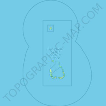
Name: Topografische Karte Ilhas Coco, Höhe, Relief.
Ort: Ilhas Coco, Austrália (-12.41188 96.61158 -11.62124 97.13496)
Durchschnittliche Höhe: 0 m
Minimale Höhe: -1 m
Maximale Höhe: 20 m
As Ilhas Cocos (Keeling) consistem em dois atóis de corais, planos, com uma área de cerca de 14,2 km², 2,6 km de linha de costa, e altitude máxima de 5 m. Estão densamente cobertas por coqueiros e outra vegetação. O clima é agradável, moderado por ventos de sudeste durante cerca de nove meses por ano e com precipitação moderada. Os ciclones podem ocorrer nos primeiros meses do ano.
Andere topografische Karten
Klicken Sie auf eine Karte, um ihre Topografie, ihre Höhe und ihr Relief anzuzeigen.
Louth
Austrália > Nova Gales do Sul > Bourke Shire Council
Louth, Bourke Shire Council, Nova Gales do Sul, 2840, Austrália
Durchschnittliche Höhe: 124 m
Blacktown City Council
Blacktown City Council, Nova Gales do Sul, Austrália
Durchschnittliche Höhe: 47 m
Frances
Frances, Hinchinbrook Shire, Queensland, Austrália
Durchschnittliche Höhe: 76 m
Proserpine
Proserpine, Whitsunday Regional, Queensland, Austrália
Durchschnittliche Höhe: 10 m
Passchendaele
Passchendaele, Southern Downs Regional, Queensland, Austrália
Durchschnittliche Höhe: 807 m
Shire Of Halls Creek
Austrália > Austrália Ocidental
Shire Of Halls Creek, Austrália Ocidental, 6770, Austrália
Durchschnittliche Höhe: 347 m
Point Ross
Point Ross, Norfolk Island, Ilha Norfolk, 2899, Austrália
Durchschnittliche Höhe: 18 m
Innisfail
Innisfail, Cassowary Coast Regional, Queensland, 4860, Austrália
Durchschnittliche Höhe: 12 m
Newman
Austrália > Austrália Ocidental
Newman, Shire Of East Pilbara, Austrália Ocidental, 6753, Austrália
Durchschnittliche Höhe: 526 m
Gladstone
Gladstone, Gladstone Regional, Queensland, 4680, Austrália
Durchschnittliche Höhe: 24 m
Flying Fish Cove
Flying Fish Cove, Shire of Christmas Island, Ilha Christmas, 6798, Austrália
Durchschnittliche Höhe: 88 m
Osaca Tank
Austrália > Nova Gales do Sul > Unincorporated Area > Wanaaring
Osaca Tank, Wanaaring, Unincorporated Area, Nova Gales do Sul, Austrália
Durchschnittliche Höhe: 95 m
Cairns
Cairns, Cairns Regional, Queensland, 4870, Austrália
Durchschnittliche Höhe: 176 m
Shire of Cocos (Keeling) Islands
Shire of Cocos (Keeling) Islands, Ilhas Coco, 6799, Austrália
Durchschnittliche Höhe: 0 m
Marrickville
Austrália > Nova Gales do Sul > Sydney
Marrickville, Inner West, Sydney, Inner West Council, Nova Gales do Sul, 2204, Austrália
Durchschnittliche Höhe: 17 m
Shire Of Wyndham-East Kimberley
Austrália > Austrália Ocidental
Shire Of Wyndham-East Kimberley, Austrália Ocidental, Austrália
Durchschnittliche Höhe: 165 m
Kununurra
Austrália > Austrália Ocidental
Kununurra, Shire Of Wyndham-East Kimberley, Austrália Ocidental, 6743, Austrália
Durchschnittliche Höhe: 74 m
Sydney
Sydney, Council of the City of Sydney, Nova Gales do Sul, Austrália
Durchschnittliche Höhe: 53 m
Whyalla
Austrália > Austrália Meridional
Whyalla, The Corporation of the City of Whyalla, Austrália Meridional, 5600, Austrália
Durchschnittliche Höhe: 5 m
Kwolyin
Austrália > Austrália Ocidental
Kwolyin, Shire Of Bruce Rock, Austrália Ocidental, 6385, Austrália
Durchschnittliche Höhe: 286 m
Nowra
Nowra, Shoalhaven City Council, Nova Gales do Sul, 2541, Austrália
Durchschnittliche Höhe: 21 m
Katoomba
Austrália > Nova Gales do Sul > Sydney
Katoomba, Sydney, Blue Mountains City Council, Nova Gales do Sul, 2780, Austrália
Durchschnittliche Höhe: 912 m
Kingston
Kingston, Norfolk Island, Burnt Pine, Ilha Norfolk, 2899, Austrália
Durchschnittliche Höhe: 49 m
Tamborine Mountain
Tamborine Mountain, Scenic Rim Regional, Queensland, 4272, Austrália
Durchschnittliche Höhe: 241 m
Newport
Austrália > Nova Gales do Sul > Sydney
Newport, Sydney, Northern Beaches Council, Nova Gales do Sul, 2106, Austrália
Durchschnittliche Höhe: 27 m
Darwin Waterfront Precinct Municipality
Darwin Waterfront Precinct Municipality, Território do Norte, Austrália
Durchschnittliche Höhe: 6 m
Rural City of Benalla
Rural City of Benalla, Victoria, Austrália
Durchschnittliche Höhe: 294 m
North Burnett Regional
North Burnett Regional, Queensland, Austrália
Durchschnittliche Höhe: 277 m
Rural City of Wangaratta
Rural City of Wangaratta, Victoria, Austrália
Durchschnittliche Höhe: 435 m
Mount Warning
Mount Warning, Tweed Shire Council, Nova Gales do Sul, 2484, Austrália
Durchschnittliche Höhe: 209 m
Wangaratta
Wangaratta, Rural City of Wangaratta, Victoria, Austrália
Durchschnittliche Höhe: 148 m
Orange
Orange, Orange City Council, Nova Gales do Sul, 2800, Austrália
Durchschnittliche Höhe: 852 m
Brisbane
Austrália > Queensland > Brisbane
Brisbane, Queensland, 4004, Austrália
Durchschnittliche Höhe: 45 m
North Hobart
North Hobart, Hobart, City of Hobart, Tasmânia, 7000, Austrália
Durchschnittliche Höhe: 71 m
Kamay Botany Bay National Park
Austrália > Nova Gales do Sul > Sydney
Kamay Botany Bay National Park, Kurnell, Sutherland Shire, Sydney, Sutherland Shire Council, Nova Gales do Sul, 2231, Austrália
Durchschnittliche Höhe: 6 m
Sydney
Austrália > Nova Gales do Sul > Sydney
Sydney, Council of the City of Sydney, Nova Gales do Sul, 2000, Austrália
Durchschnittliche Höhe: 32 m
Witjira National Park
Austrália > Austrália Meridional > Pastoral Unincorporated Area
Witjira National Park, Witjira, Pastoral Unincorporated Area, Austrália Meridional, 5734, Austrália
Durchschnittliche Höhe: 129 m
Norah Head
Norah Head, Central Coast Council, Nova Gales do Sul, 2263, Austrália
Durchschnittliche Höhe: 9 m